|
||

|

|
|

|
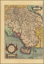
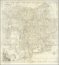
Rare separately published map of the March of Ancona, published by Luchini in 1564.
The map includes the cities of Fermo, Macerata, Ancona, Urbino, Camerino, along with two large coats of arms.
The map illustrates the ancient region of Ancona, during a period when it was a Territory of the Papal States.
Originally part of Imperial Italy, the region was constituted around 1100 from the March of Fermo and a southern portion of the Byzantine Pentapolis. Initially the March took the name of its first ruler: Marca Guarnerii or March of Werner. There were disputes between the Empire and the Church over rights and jurisdiction in the March. In 1173, an imperial army under Christian of Mainz invaded the March against pro-papal resistance led by Countess Boltruda Frangipani. In 1177, Pope Alexander III referred to it as "partly belonging to the empire but largely to the church".
The March was taken by the Papal States during the pontificate of Innocent III in the year 1198. It was initially governed by a papal nominee called a rector. The rector of Ancona, like the rectors of other papal provinces, was under the authority of a general rector reporting directly to the pope. Under the papacy, the March had three towns of over 10,000 people: Ancona, Ascoli Piceno and Fermo.
The province was reorganized by the Constitutiones Sanctæ Matris Ecclesiæ in 1357. The March followed the Adriatic as far north as Urbino and contained the cities of Loreto, Camerino, Fermo, Macerata, Osimo, San Severino, and Tolentino.
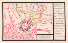
![[ Torino / Turin Battle Plan ] Plan de la Ville et Citadelle de Turin Assiegees par l'Armee de France. le 3e Juin 1706 et Secourues par leurs Altes ses Royale et Serenissme de Savoye, le 7.e. Septembre de la meme Annee . . .](https://storage.googleapis.com/raremaps/img/small/80453.jpg)