|
||

|

|
|

|
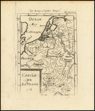
Rare, Early Map of Eastern France Based on a Map Suppressed By The Duke of Alba
Scarce sixteenth-century map of Franche-Comté, bearing the credit "N.V.A. formis 1596".
The map is oriented with east at the top, and extends to the Saone River in the south and the Alps in the east. It is centered on the region east of Besançon, including Poligny, Quingey and St. Anne.
The map is thickly detailed with rolling hills, tiny villages, walled cities, and winding rivers. The coat of arms of Burgundy, with its rearing lion with a lolling tongue, is in the upper left corner. The scale is in Burgundian miles.
This map is based upon an earlier 1563 map by Ferdinand de Lannoy, a Flemish noble who was the Governor of Holland for a brief period. Lannoy commissioned the Antwerp publisher Hieronymus Cock to produce a printed version of the map and it is known that in 1568 the copperplate was finished. For reasons of military security, however, the Duke of Alba ordered the map not to be released. He had the plate destroyed. Therefore, no printed copy of this base map is known to date. This earlier map is also confirmed by Abraham Ortelius’ description in his Auctorum Catalog of 1570.
The present map, dated to 1596, was made in Rome. N.V.A. would be Nicholas Van Aelst, a Flemish printmaker and publisher operating in Rome at the turn of the seventeenth century, who is also likely to have had access to the original Lannoy map through his sources in the low countries.
Franche-Comté
This important region in what is now eastern France became part of the Frankish kingdom in the early sixth century. It then came under the control of Burgundy in 561 before being united with the Frankish kingdom under Clotaire II of Burgundy in 613. It remained a territory of the County of Burgundy from 888 and came under the umbrella of the Holy Roman Empire in 1034. The name Franche-Comté first appeared in official documents in 1366.
In 1477, the territory was separated from the Duchy of Burgundy because the latter had been incorporated into the larger kingdom of France. When King Louis XI died in 1492 the entire Duchy was ceded to Philip of Austria. Philip’s son, the powerful Charles V, inherited the Spanish throne in 1516, placing Franche-Comté and Burgundy in Spanish hands. This is why the Duke of Alba, a Spanish noble, was able to suppress the publication of the source map by Lannoy.
The area was of immense interest to the French, who saw it as a natural part of their kingdom. It was only won back to France, however, in 1668, but was then returned to Spain in the Treaty of Aix-la-Chapelle. France again seized the territory in 1674 and they gained permanent control over Franche-Comté in the Treaty of Nijmegen in 1678.
Rarity
This is only the fifth known example of the map, according to Bifolco-Ronca.
The Lafreri School is a commonly used name for a group of mapmakers, engravers, and publishers who worked in Rome and Venice from ca. 1544 to 1585. The makers, who were loosely connected via business partnerships and collaborations, created maps that were then bound into composite atlases; the maps would be chosen based on the buyer or compiler’s interests. As the maps were initially published as separate-sheets, the style and size of maps included under the umbrella of the “School” differed widely. These differences can also be seen in the surviving Lafreri atlases, which have maps bound in with varying formats including as folded maps, maps with wide, trimmed, or added margins, smaller maps, etc.
The most famous mapmakers of the School included Giacomo Gastaldi and Paolo Forlani, among others. The School’s namesake, Antonio Lafreri, was a map and printseller. His 1572 catalog of his stock, entitled Indice Delle Tavole Moderne Di Geografia Della Maggior Parte Del Mondo, has a similar title to many of the composite atlases and thus his name became associated with the entire output of the larger group.
Ferdinand de Lannoy , Duke of Boyennes, was a Spanish general, born in Italy around 1510, died in 1579. He is the son of Charles de Lannoy .
Ferndinand de Lannoy, lord de Laroche served as one of the officers in the army of Charles V, under the command of Prince William of Orange. He was also known as La Roche.
In second marriage was married to Marguerite de Lannoy Perrenot, sister of Cardinal Granvelle. Lannoy was appointed governor of Artois and remained in the conflict of the Rebellion royalist and Catholic. When the royal governor of Holland, Count Maximilian of Boussu, had fallen into the hands of the insurgents, Lannoy was appointed stadtholder of Holland. Since the bulk of Holland was in the hands of the rebels, he stayed mostly in Utrecht.
Shortly after the siege he gave up the governorship of Holland and limited himself to that of Arras. Lannoy settled in one of his castles in the Franche-Comte, where he died in 1579.
Lannoy was as distinguished as a scholar as he was as a man of war. He is considered the inventor of the field artillery, and produced some of the earliest modern maps of Burgundy and Franche-Comté.
When the Duke of Alba marched north from Italy into the Netherlands in 1567, he used a map of Franche-Comté prepared by Ferdinand de Lannoy. The publication was delayed for a decade, but it appeared in the 1579 edition of Ortelius’s Theatrum orbis terrarum.
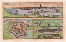
![[Besançon] Vesontio Sequanorum Gallis Bensan son Germanis Byzantz](https://storage.googleapis.com/raremaps/img/small/76977.jpg)
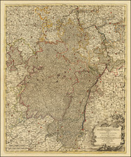
![[Duke of York's Copy] Le Toulois ou sont Les Chatellenies et Les Prevotes du Temporel de l'Eveche de Toul et de son Chapitre; Partie du Balliage de l'Eveche de Verdun. Le Duche de Barrois ou Balliage de Bar le Duc . . .](https://storage.googleapis.com/raremaps/img/small/71292.jpg)