|
||

|

|
|

|
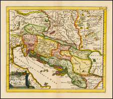
Fantastic large map of central Europe, showing the region from Italy through to Romania and the Black Sea, and as far north as Krakow and Prague. This fine regional map includes a vast amount of detail, naming many towns and rivers. Cities of importance, such as Bucharest, Vienna, and Constantinople are highlighted in red.
The map is particularly interesting for its complete neglect of any reference to the Ottoman Empire. This map was published at a time during which the entity still controlled parts of the region, yet while it was declining rapidly in importance. Many in the Christian world sought to downplay the importance of the empire, which may have contributed to this feature. In addition, political boundaries were constantly being redrawn, meaning that it was better to refer to historical regions in mapmaking.
The map includes a decorative cartouche in the lower left, including a portrait of a Hapsburg ruler. This map was originally published in 1688 by Fredrik de Wit. Covens and Mortier eventually inherited his plates, and it was here reissued in around 1725.
Covens & Mortier was one of the largest and most successful publishing firms in Dutch history and continued in business for over a century. Pierre Mortier the Elder (1661-1711) had obtained a privilege in 1690 to distribute the works of French geographers in the Netherlands. After his widow continued the business for several years, Cornelis (1699-1783) took over in 1719.
In 1721, Mortier forged a partnership with Johannes Covens (1697-1774), who had recently married Cornelis’ sister. They published under the joint name of Covens & Mortier. In 1774, upon the death of his father, Johannes Covens II (1722-1794) took over his father’s share. In 1778, the company changed its name to J. Covens & Zoon, or J. Covens & Son.
Covens II’s son, Cornelis (1764-1825), later inherited the business and brought Petrus Mortier IV back into the fold. Petrus was the great-grandson of Petrus Mortier I. From 1794, the business was called Mortier, Covens & Zoon, or Mortier, Covens, & Son.
The business specialized in publishing French geographers including Deslisle, Jaillot, Janssonius, and Sanson. They also published atlases, for example a 1725 reissue of Frederik de Wit’s Atlas Major and an atlas, with additions, from the works of Guillaume Delisle. There were also Covens & Mortier pocket atlases and town atlases. The company profited from acquiring plates from other geographers as well. For example, the purchased Pieter van der Aa’s plates in 1730. Finally, they also compiled a few maps in house. At their height, they had the largest collection of geographic prints ever assembled in Amsterdam.
![Istria e Alpi Giulie [Istria and Julian Alps]](https://storage.googleapis.com/raremaps/img/small/88209.jpg)
![(Central Europe and Hungary) Ungria Restaurada compendiosa noticia, de dos tiempos: del Passado. Baxo el Jugo de la Tirania Othomana, del Presente, Baxo el Dominio Catholico de Leopoldo II de Austria. [Hungary Restored, Extensive Notices about].](https://storage.googleapis.com/raremaps/img/small/68278.jpg)