


|
||

|

|
|

|
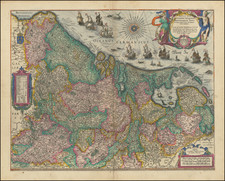
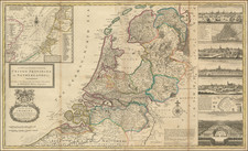
One of the Rarest Maps of Flanders (and Zeeland)!
Rare third state of the Van Langren brothers map of Flanders and Zeeland, published in Amsterdam in about 1610 by David de Meyne.
The present map was for many years an unrecognized precursor to Claes Janz Visscher's carte-a-figures map Flandria Comitatus, first issued in 1621. However, in a 1996 article by Franz Gittenberger in Caert Thressoor entitled Kaarten, platen en staten: C.J. Visschers Comitatus Flandria met randgezichten thuisgebracht, identified for the first time the existence of a link between an earlier map engraved in Amsterdam by the Van Langrens and published by Cornelis Claesz in about 1595 was in fact the original map, which would be later reworked extensively by CJ Visscher to create the Carte-a-Figures editions of the map, first issued in 1621. As noted by Gittenberger:
The well-known map by Claes Jansz. Visscher with views of Flanders has kept a secret for a long time, that for the most part it was a quarter of a century older than previously believed. Even the most recent literature has failed to describe this map printed from two copper plates as not engraved from two larger plates originally engraved by Visscher himself but instead by the Arnold brothers and Hendrik van Langren [in about 1595].
The map was originally a much rarer map with two titles, Flandria and Zelandiae Comitatus, on which both provinces are very remarkably merged in one map image . . .
Five different states of theVisscher Map wree previously known up to now, to which we can now add four older states, namely two
van de Van Langren, one from David de Meyne and one Visscher himself.[For the third state], the only change from the second state is the addition of the address of De Meyne (1569-before 1620) at the bottom left. Information about the existence of this state was provided to the authort by Professor [Gunter] Schilder.
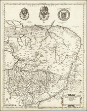
Early States of the Map and Rarity
The map is very rare, with only 2 examples of each of the first 3 states known and only 1 example of the fourth state known.
- State 1: Imprint of Van Langrens. No forts around Biervliet Island (BNF and Gitternberger Collection)
- State 2: Imprint unchanged. Six forts added (Ysendonck, Paciencie, Philippine, 't-Sas, Terneuse and Mauritius For, the last of which, Mauritius, was built in 1588 (University of Leiden and Middleburg Zeeuwsch Genootschap)
- State 3: Imprint of "'t Amsterdam: gedruckt bij David de meine inde werelt cart" added (National Library of Spain and Vincennes Service Historique de la Marine (Paris)).
- State 4: Imprint of "'t Amsterdam: gedruckt bij Claes Janss Visccher inde Calverstaet in de Visscher" replacing"De Meyne imprint (Private Belgian collection -- Atlas Iprensis)
The map is listed as previously unknown by Tony Campell in the Chronicle for 1979-80: Imago Mundi, Vol. 32 (1980), pp. 90-94 (1980) (page 94), listed in Rober Douwma Catalog 22.
Arnold Florent van Langren (1580-1644) was a member of a prominent family of engravers. Along with his father, Jacob, and brother, Henricus, he produced globes. The Van Langren family was granted a monopoly over globe production by the States General in 1592. The brothers also engraved maps. In 1609, Arnold moved his family from Amsterdam to Antwerp, where his sons Jacob and Michael joined the business.
Dutch engraver and painter, active between about 1595 and 1620 in Amsterdam.
De Meyne was known to have been a colleague of the publisher Cornelis Claesz., known to have worked together with Petrus Plancius. A number of Plancius’ maps were later issued by De Meyne, which had originally belonged to Claesz.
De Meijn is known to have sold his stock to Clase Jansz Visscher in 1620.
![[Proposed Canal / Utrecht to the Sea] Nieuwe en Nette Aftekening van de Door Gravinge die er staat te Geschieden beginnende van de Stadt Utrecht to aan Spakenborg in de Zuyder Zee met des zelfs Afbakinge &c](https://storage.googleapis.com/raremaps/img/small/94380.jpg)