
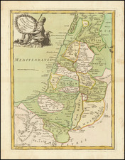
![[The Travels of Paul] Tabula Geographica, in qua omnes regiones, urbes, oppida, et loca describuntur, quorum mentio fit in Actis et Epistolis Apostolotum, et Apocalypsi; de integro multis in locis emendata, ac regionum limitibus distincta, auct. Pet. Planc. . . . By D.R.M. Mathes](https://storage.googleapis.com/raremaps/img/small/77970.jpg)


|
||

|

|
|

|
Plancius' Map of the Eastern Mediterranean Showing the Travels of Paul The Apostel
Finely engraved map of the eastern Mediterranean, engraved by Baptista Van Deutecum and printed in Amsterdam for Ian Evertsz Cloppenborch.
The map shows the regions around the Mediterranean; present-day Italy, Greece, Turkey, Syria, Israel, northern Egypt and the northern coastline of Africa.
The map is ringed by 15 images of scenes from the Acts of the Apostles and the Revelation of John, including:
- 1 - Foundation of the Christian congregation / outpouring of holy spirit on 120 disciples of Christ (Acts 2).
- 2 - About 3,000 converts baptized based on Peter's testimony and speech (Acts 2)
- 6 - Martyrdom of Stephen (Acts 7)
- 8 - Conversion of Saul of Tarsus (Acts 9)
- 9 - Peter receiving a vision of unclean animals and is commanded to slaughter and eat (Acts 10).
- 11 - The stoning of Paul in Lystra, left for dead outside the city (Acts 14).
- 14 - A seven-headed wild beast is ridden by a harlot and its judgment is executed (Rev. 17).
The map is one of a set 6 maps engraved by Baptista Van Deutecum, from the second set of Bible maps prepared for Plancius. This second set follows his set of 5 map printed about 1590. Plancius felt the need to create this second set of maps The graphic realization was provided by Baptista van Deutecum from Amsterdam. The result was a series of 6 Bible maps and a bird's-eye projection of the city of Jerusalem, which were more decorative and elaborate in appearance. The set was so successful that it would be re-issued until 1623 and thereafter copied by D.R.M Mathes' (circa 1625) and adapted by Joost Hartgers (1653).
Rarity
The separate Plancius maps are rare on the market.
Petrus Plancius (1552-1622) was born Pieter Platevoet in Dranouter in West Flanders. He trained as a clergyman in Germany and England, but he was an expert not only in theology but in geography, cosmography, and navigation. After fleeing prosecution by the Inquisition in Brussels, Plancius settled in Amsterdam where he first began his forays into navigation and charting. As Amsterdam was a hub for trade, Plancius was able to access Portuguese charts, the most advanced in the world at that time. Plancius used these charts to become an expert in the sailing routes to India, knowledge that gained him opportunity. Plancius was one of the founders of the VOC, for whom he worked as their geographer. He also served on a Government Committee to review the equipment needed for exploratory expeditions.
![(Second World War - Balkans) Karte von Südosteuropa [Map of Southeastern Europe]](https://storage.googleapis.com/raremaps/img/small/90544.jpg)
![[Kingdom of Persia] Regno di Persia con le notitie Provincie Antiche, che piu probabilmente corrispondono alle Divisioni moderne d'esso Regno . . . 1679](https://storage.googleapis.com/raremaps/img/small/75921.jpg)
![Turcia Turci Cive Imperii seu Solij mannorum regni pleraque pars nunc recens Summa fide ac indusrai elucubrata | Natoliam Moderni dicunt tam partem quam Asiam minrem appelauere veteres. [shows Cyprus]](https://storage.googleapis.com/raremaps/img/small/86757.jpg)
![[ Italy - Wall Map - Rare Variant ] Gran Carta D' Italia - Pubblicata Da Giuseppe Civelli De Milano - Edizione Metagrafica per Fedinando Angemnillon](https://storage.googleapis.com/raremaps/img/small/101467.jpg)