|
||

|

|
|

|
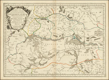
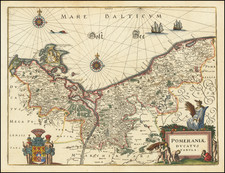
Rare First State!
Fine old color example of the first state of Claesz Jansson Visscher's rare map of map of Prussia, engraved by Abraham Goos and bearing the date of 1630.
The map includes a large inset birdseye view of Konigsberg, 5 sailing ships and decorative cartouche.
The map was drawn from the original map of Prussian village priest Caspar Henneberger in 1576. Caspar Hennenberger (1529 -1600) was a German Lutheran pastor, historian and cartographer. He studied Lutheran divinity at the University of Königsberg in 1550. In 1554 he began to work at the congregation of Georgenau and in Domnau. About 1561 he moved to Mühlhausen, where he worked as a Lutheran Pastor for the next 29 years.
With the patronage of Duke Albert of Prussia, and support by Prussian mathematicians like Nicolaus Neodomus, Hennenberger published the first detailed map of Prussia in 1576, as well as the book "Kurze und wahrhaftige Beschreibung des Landes zu Preussen" (short and truthful description of the land Prussia) in 1584 and "Erklärung der preußischen größeren Landtafeln oder Mappen" (explanation of the larger Prussian maps) in 1594.
Rarity
This is only the second example of the 1630 edition of the map we have ever seen on the market and the only one in original color.
![[Gdansk] La Ville de: Danzic, dans la Prusse Royale.](https://storage.googleapis.com/raremaps/img/small/85303.jpg)