|
||

|

|
|

|
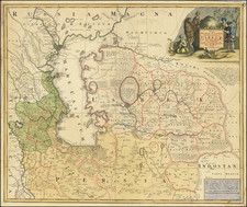
Nice example of John Speed's map of Russia, from the 1676 edition of Speed's Prospect of The Most Famous Parts of the World. . . , published by Bassett & Chiswell.
This fine plan of Russia was based on Blaeu's maps published in the middle of the 17th century but shows Speed's English decorative tendencies. The map, almost as vast in scope as the country it portrays, extends westwards to Poland and Scandinavia, and shows all of the Baltic States, Ukraine, and the Black Sea. Eastwards, the map shows the start of Siberia, including the mouth of the vast Ob River. The Caspian Sea is shown in full. From the Dnieper to the Volga, a strange representation of a "Great Wall of Russia" is shown in the Lipetsk region, one that Putin has recently vowed to revive.
The map includes a number of views showing Arkhangelsk on the north coast, the emperor's court, Narva Castle, as well as a Russian mill and a "hot house" (sauna). Also shown is a fantastic plan of the city of Moscow, including a legend naming places of interest.
The 1676 edition of Speed's Prospect was the first edition in fifty years to include new maps. For this edition, the new publishers (given that Speed was long dead) added this map of Russia, along with maps of Southeast Asia, New England and New York, Virginia and Maryland, Carolina, Jamaica and Barbados, Bermuda, and Canaan. As a result, these are by far the scarcest of the regional maps from Speed's Atlas.
John Speed (1551 or '52 - 28 July 1629) was the best known English mapmaker of the Stuart period. Speed came to mapmaking late in life, producing his first maps in the 1590s and entering the trade in earnest when he was almost 60 years old.
John Speed's fame, which continues to this day, lies with two atlases, The Theatre of the Empire of Great Britaine (first published 1612), and the Prospect of the Most Famous Parts of the World (1627). While The Theatre ... started as solely a county atlas, it grew into an impressive world atlas with the inclusion of the Prospect in 1627. The plates for the atlas passed through many hands in the 17th century, and the book finally reached its apotheosis in 1676 when it was published by Thomas Bassett and Richard Chiswell, with a number of important maps added for the first time.
![(Second World War - Operation Barbarossa) A M. Kir. VIII. Honv. LGV. O. Hazamenetelének útja mecsebjelovkától kassáig [The Hungarian 8th Anti-Aircraft Battalion's Homeward Route from Mechebylove to Kosice]](https://storage.googleapis.com/raremaps/img/small/90242.jpg)
![Западное Полушариіе | Восточное Полушаріе [Western Hemisphere | Eastern Hemisphere]](https://storage.googleapis.com/raremaps/img/small/82868.jpg)
![[ Scandinavia ] Tabula Geographica Regnorum Sueciae Daniae et Norwegiae](https://storage.googleapis.com/raremaps/img/small/102797.jpg)