


|
||

|

|
|

|
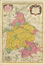
Fine original antique map of the Swabian region of southern Germany, published in Amsterdam by the Visscher family at the end of the 17th century. The extremely attractive map shows the German region around the French and Swiss border in extensive detail, with cities, towns, and more all shown.
The legend in the lower left of the map shows just how expansive the information provided is. Not only are major cities listed, but also are all the different types of cities differentiated (imperial free cities, capitals, etc.), universities are shown, bishoprics and venerated sites denoted, and much more. The map also includes a very decorative title cartouche and scale bar.
A number of important cities are shown on the map, including Stuttgart, Heilbronn, Basel, and Strasburg. Roads are shown. In all, a detailed and attractive map.
Nicolaas Visscher II (1649-1702) was a prominent Dutch cartographer and publisher during the late 17th century. He was the grandson of Claes Janszoon Visscher and the son of Nicolaes Visscher I, both of whom were also renowned cartographers in their own right. After his father's death in 1679, Nicolaas Visscher II took over the family's map publishing business.
In 1680, he married Elizabeth Verseyl from Gouda, and in 1682, he obtained a new privilege from the States of Holland and West Friesland to protect his maps and publications from being copied. Visscher II continued the family tradition of producing high-quality maps, atlases, and globes, often with elaborate and decorative elements. He maintained the Visscher family's reputation for accuracy and craftsmanship in the competitive world of Dutch cartography until his death in 1702. After his death, his widow, Elizabeth, and later his son, also named Nicolaas, continued the business until around 1726.
![[Rhine River Region -- Basle to Strassbourg]](https://storage.googleapis.com/raremaps/img/small/75325.jpg)
![[Rhine River Region -- Basle to Strasbourg]](https://storage.googleapis.com/raremaps/img/small/75443.jpg)