|
||

|

|
|

|
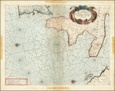
The First Printed Regional Map of Italy, and the First Separately-Issued Map of Sicily. One of Gastaldi's Earliest Creations.
Superlative map of Sicily, being the first map of the island and a fine early work of the great Lafreri School cartographer Giacomo Gastaldi. The map was published in 1545 at his Venetian publishing house and represents a compendium of Ptolemaic and modern sources.
Highly decorative, the stylistic tendencies are distinct of the early Lafreri School and would be changed with later publications. The sea shows a rippled texture, rather than the more common stippled pattern. Hills are slightly less rounded and they are shaded. Finally, the cities shown are very Medieval. Notice, particularly, "La falconara" tower in the center of the south coast. Also, note Etna (M. Gibello) in firey eruption.
The map represents a cartographic achievement, as Bifolco and Ronca term it the first regional map produced in Italy. Famoso refers to the map as "a turning point for Sicily's representations. . . the cornerstone of Sicilian cartography." It is believed (according to Almagia and others) that Gastaldi collaborated on the project with Francesco Maurolico, a Sicilian mathematician who would produce a Descrittione dell'isola di Sicilia in 1546, also in Venice. The distances and toponyms are likely drawn from Maurolico.
The island is divided into three regions: the Val de Noto, Val de Mona, and the Val de Mazzara. Note that these are not "valles" (valleys), but vallos, subdivisions of the island carried over from the Arabic and Norman epoch of the island.
In all a great map of Sicily, one that would serve as the basis for future maps for over a century. Tooley refers to it as the biggest Lafreri School map of the island.
The Lafreri School is a commonly used name for a group of mapmakers, engravers, and publishers who worked in Rome and Venice from ca. 1544 to 1585. The makers, who were loosely connected via business partnerships and collaborations, created maps that were then bound into composite atlases; the maps would be chosen based on the buyer or compiler’s interests. As the maps were initially published as separate-sheets, the style and size of maps included under the umbrella of the “School” differed widely. These differences can also be seen in the surviving Lafreri atlases, which have maps bound in with varying formats including as folded maps, maps with wide, trimmed, or added margins, smaller maps, etc.
The most famous mapmakers of the School included Giacomo Gastaldi and Paolo Forlani, among others. The School’s namesake, Antonio Lafreri, was a map and printseller. His 1572 catalog of his stock, entitled Indice Delle Tavole Moderne Di Geografia Della Maggior Parte Del Mondo, has a similar title to many of the composite atlases and thus his name became associated with the entire output of the larger group.
Fabian Famoso "THE FEATURES OF SICILY IN CARTOGRAPHY"
Tooley 514
Giacomo Gastaldi (1500-1566) is considered the foremost Italian cartographer of the sixteenth century, alongside Paolo Forlani. His skills of compilation are comparable to those of Mercator and Ortelius, yet much less is known of his life than of his two contemporaries. Gastaldi was born in Villafranca, Piedmont, but had established himself in Venice by 1539. He originally worked as an engineer, but turned to mapmaking from the 1540s onward.
It was in Venice where he made his reputation as an engraver, geographer, and cosmographer; for example, he was asked to fresco maps of Asia and Africa in the Palace of the Doge, or the Council of Ten, Venice’s governmental body. He also frequently consulted on projects for the Savi sopra la Laguna, drawing maps for this body which oversaw the regulation of fresh and salt water around Venice.
His contemporaries also recognized his skill, as he was named cosmographer to the Republic of Venice, was a member of the Accademia Veneziana, and was a major source for other geographers and mapmakers including Camocio, Bertelli, Cock, Luchini, and Ortelius. He even had his own distinct style of copper engraving that made him a pioneer in his day and makes his works iconic today.
Gastaldi enjoyed an especially productive relationship with Giovanni Battista Ramusio, Secretary of the Venetian Senate, who used Gastaldi's maps for his famous travel account collection, Navigationi et Viaggi. Gastaldi also tutored Ramusio's son in cosmography.
![(Sicily, Sardinia, and Corsica) Tabu. Moder. Sicili & Sardi. [Modern Map of Sicily and Sardinia]](https://storage.googleapis.com/raremaps/img/small/102705.jpg)
![[Messina] Messana Urbs est Sicilie . . .](https://storage.googleapis.com/raremaps/img/small/77027.jpg)