|
||

|

|
|

|
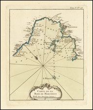
Rare map of the 1542 Battle of Perpignan, published in Rome by Enea Vico in that year. The marvelous and busy image shows the attack by the French on the then-Spanish-held city, which would prove to be ultimately unsuccessful.
The map shows the siege of the city as seen from the perspective of the coast, with the Pyrenees looming in the background. Carcassonne appears in the upper right, with the Aude River passing by. Narbonne appears on the coast. The different armies that participated in the siege are all labeled.
The siege in question was the 1541 French siege of the city of Perpignan. Following the disastrous Spanish invasion of the city of Algiers, the French powers had decided that it was time to attempt to take the Spanish-held region of Perpignan. However, once they laid siege to the city, the Spanish captain guarding the town launched a surprise attack on the French heavy artillery positions, destroying much of the firepower and forcing the end of the invasion. The French would not take the city until 1642.
Two Lafreri School views of the Battle of Perpignan exist, of which this view is the rarer and more finely engraved of the two. Vico was an early Lafreri School publisher whose maps are very rare on the market today, with this being the first map we have offered that he has produced. Vico also engraved a map to show the extent of the 1542 war.
Rarity
Bifolco and Ronca's unusually complete census of this map locates only two copies of this map within the United States, including the presented example.
The Lafreri School is a commonly used name for a group of mapmakers, engravers, and publishers who worked in Rome and Venice from ca. 1544 to 1585. The makers, who were loosely connected via business partnerships and collaborations, created maps that were then bound into composite atlases; the maps would be chosen based on the buyer or compiler’s interests. As the maps were initially published as separate-sheets, the style and size of maps included under the umbrella of the “School” differed widely. These differences can also be seen in the surviving Lafreri atlases, which have maps bound in with varying formats including as folded maps, maps with wide, trimmed, or added margins, smaller maps, etc.
The most famous mapmakers of the School included Giacomo Gastaldi and Paolo Forlani, among others. The School’s namesake, Antonio Lafreri, was a map and printseller. His 1572 catalog of his stock, entitled Indice Delle Tavole Moderne Di Geografia Della Maggior Parte Del Mondo, has a similar title to many of the composite atlases and thus his name became associated with the entire output of the larger group.
![Disegno Particolare del Piemonte et Monferrato e suoi confini [Detailed Map of Piedmont and Monferrato and their boundaries.]](https://storage.googleapis.com/raremaps/img/small/75464.jpg)