


|
||

|

|
|

|
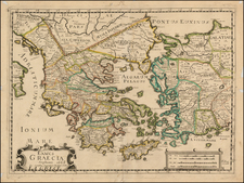
First edition of John Speed's decorative map of Greece. Showing the region as it was two thousand years ago, the map names historical region such as Attica (the peninsula which contains Athens) and Laconia (the province ruled by Sparta). This was the first folio-sized map of Greece published in England.
The map extends north to include part of the Black Sea, and large regions of Turkey and the Balkans are also visible. The title cartouche names the region both in English and in Greek.
This is a highly detailed early depiction of Greece, and it contains a fascinating English text description on the verso.
John Speed (1551 or '52 - 28 July 1629) was the best known English mapmaker of the Stuart period. Speed came to mapmaking late in life, producing his first maps in the 1590s and entering the trade in earnest when he was almost 60 years old.
John Speed's fame, which continues to this day, lies with two atlases, The Theatre of the Empire of Great Britaine (first published 1612), and the Prospect of the Most Famous Parts of the World (1627). While The Theatre ... started as solely a county atlas, it grew into an impressive world atlas with the inclusion of the Prospect in 1627. The plates for the atlas passed through many hands in the 17th century, and the book finally reached its apotheosis in 1676 when it was published by Thomas Bassett and Richard Chiswell, with a number of important maps added for the first time.
![(Atlas of the Aegean -- Extra Illustrated!) L'Egeo redivivo o' sia chorographia dell' arcipelago, e dello stato primiero, & attuale di quell' isole. . . [The Aegean revived, or the chorography of the archipelago, and of the original and current state of those islands. . .]](https://storage.googleapis.com/raremaps/img/small/93229.jpg)
![Turcia Turci Cive Imperii seu Solij mannorum regni pleraque pars nunc recens Summa fide ac indusrai elucubrata | Natoliam Moderni dicunt tam partem quam Asiam minrem appelauere veteres. [shows Cyprus]](https://storage.googleapis.com/raremaps/img/small/86757.jpg)