|
||

|

|
|

|
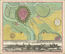
Fantastic Lafreri School bird's-eye view of the 1567 Siege of Gotha, the culmination of the "rather bizarre" Grumbach Feud period of the Holy Roman Empire. Engraved in fine Italian detail, the map was engraved in Venice by Nicolo Nelli in the same year as the aforementioned siege.
This fine copperplate engraving shows in grand detail the fortified city of Gotha, with individual buildings, wells, and more shown, and buildings of importance named. Detail extends into the countryside, with various smaller towns shown with their fields and military movements shown throughout. As with many of the superior Lafreri School prints, this view shows a remarkable and evocative eye for detail.
The map describes the siege as follows:
Alli 25 di Gennaro 1567 su posto l'asedio sotto la gran fortezza di Grimesteim insieme con la citta di Gotta dall'essercito del sacro Imperio li quali luoghi furono d'alli Cittadini dali nelle mani del Comissario dell' Imperio, all 13 di Aprile, insieme con li ribelli, et alli 17 furono seconod i loro demeriti giusticiati.
This describes the Siege of Gotha, which followed the decline of the Ernestine line of the House of Wettin. After the division of the House in 1485, this lineage had won control of the Electorate of Saxony, however, the loss of the Schmalkaldic War against the Holy Roman Emperor in 1547 led to the abdication of the Electorate, as well as any imperial privileges and the invocation of an imperial ban. A younger member of the Ernestine line, John Frederick II, took it upon himself to reclaim power for the Ernestines, and was goaded on to staking a claim to the Electorate by Willhelm von Grumbach. Grumbach's plan involved a series of unlikely events, including a general insurrection of knights and the use of magic charms. Grumbach managed to forge some alliances and plot various assassinations, and the successful siege of Gotha was one of the high points in the insurrection. However, the plan would eventually fail and John Frederick II would be imprisoned and Grumbach dismembered.
Rarity
This map is relatively rare for a Lafreri School work. Bifolco and Ronca list eight institutional examples.
The Lafreri School is a commonly used name for a group of mapmakers, engravers, and publishers who worked in Rome and Venice from ca. 1544 to 1585. The makers, who were loosely connected via business partnerships and collaborations, created maps that were then bound into composite atlases; the maps would be chosen based on the buyer or compiler’s interests. As the maps were initially published as separate-sheets, the style and size of maps included under the umbrella of the “School” differed widely. These differences can also be seen in the surviving Lafreri atlases, which have maps bound in with varying formats including as folded maps, maps with wide, trimmed, or added margins, smaller maps, etc.
The most famous mapmakers of the School included Giacomo Gastaldi and Paolo Forlani, among others. The School’s namesake, Antonio Lafreri, was a map and printseller. His 1572 catalog of his stock, entitled Indice Delle Tavole Moderne Di Geografia Della Maggior Parte Del Mondo, has a similar title to many of the composite atlases and thus his name became associated with the entire output of the larger group.
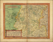
![[Thuringa] Sectio Inferior, Ducatum Vinariensem, nec non Isenacensis, Partes Boreales et Orientales, Principatum Querfurtensem, ut et Territorium Erfurtense, Comitatum Beichlingen, Balisiatum Thuringiae et alia repraesentans](https://storage.googleapis.com/raremaps/img/small/58972.jpg)