|
||

|

|
|

|
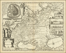
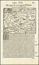
A handsome example of this exceptionally rare and important map of Russia, which was engraved by Frans Hogenberg in 1570 after the work of Anton Wied.
The map is oriented with east at the top, extending as far as the Caspian Sea. To the bottom (west) of the map is the Baltic and Kioff (Kyiv). At the right (south) of the map is the Black Sea, with "TARTARIA" extending along its northern coast. Elsewhere in Tartaria are the tent camps of the Horde ("Kalmuky Horda", "Kosary Horda", and Horda Nohay"). Russia is crossed by long strands of forest; evocative illustrations of hunting and wilderness abound; several large cities such as "Wilki Novigrad" (Veliky Novgorod), "Moscovia metropolis", "Novigrad nysni" (Nizhny Novgorod), etc. "Wiborg" (Vyborg) is the furthest-west city on the map; St. Petersburg was almost half a century away from seeing its first settlers.
Anton Wied was an artist from Danzig who accompanied Senator Johann Koppe on a mission to Vilnius in 1542 to meet with the exile Ivan Lyatsky. Wied collaborated with Lyatsky to produce a large manuscript map of Russia in 1542 based on the latter's extensive knowledge of the country. In 1555, that map was turned into a spectacular nine-sheet wall map of Russia, the first printed map in the Russian language. In turn, Hogenberg reduced either the manuscript or the nine-sheet wall map, into this single-sheet engraving. Hogenberg made changes to the format of the map, extending it at right and left to better fit it to an atlas (the original had been very nearly square). In these extensions, Hogenberg draws on cartographic sources that Leo Bagrow was unable to identify.
This map's dating to 1570 is significant, as that was the year of the first edition of Abraham Ortelius's Theatrum Orbis Terrarum, to which Frans Hogenberg (this map's engraver) contributed extensively. Indeed, Hogenberg was the engraver of the map that did make it into the Theatrum, that of Anthony Jenkinson a member of William Burrough's expedition to Russia. Jenkinson's map has wider coverage than that of Wied, extending into Central Asia, and this might have been the deciding factor when Ortelius chose that as the map for his atlas.
Leo Bagrow's Commentary
Leo Bagrow comments extensively on the Lyatsky-Wied map in his seminal work on the early mapping of Russia, A History of the Cartography of Russia Up To 1600, pages 64-68:
Somehow, it became known in Danzig that Lyatsky could provide rich descriptive material on Muscovy. Hearing this, the Senator Johann Koppe took the first opportunity to go to Vilna, taking with him Anton Wied, an artist whom he had persuaded to draw a map of Muscovy. Wied met Lyatsky and obtained from him the necessary material. In the same year, 1542, Wied prepared the manuscript of his map; being an artist, he embellished it with drawings of hunting scenes and the various wild beasts populating the Russian forests. Whether Lyatsky had helped him with these drawings we do not know, but it can be said that they are executed not only with artistry, but also with some realism, which suggests that he may have done so. Proof of this assumption seems to be found in a series of inscriptions on the map, executed in Russian with calligraphic perfection. Wied scarcely knew Russian well enough for this.
Wied's map, drawn in 1542, remained for some time as a manuscript; nevertheless it became known to a number of persons. Among them was Herberstein, to whom Wied might even have sent a copy at Lyatsky's suggestion. Reference to it is found in Gessner [(1548) 111c, 113b]; who later borrowed from Wied's map the scene of a moufflon hunt for his Historiae Animalium (1551). Still earlier, Wied had answered Munster's public appeal for geographic material for his Cosmographia. In his 1544 edition, Munster credits Wied (who was assigned by "...Johannes Jatski") with supplying him with materials on Muscovy, which apparently included text and a map. Thus Wied's map, even in this reduced and slightly simplified form, was given considerable circulation.
Wied's map comprising six sheets, has no special title. There appears, in the lower right hand corner, a dedication to "Coppe" from A. Wied which explains what the map represents and that Lyatsky had assisted in its compilation. It also mentions Herbertstein's request for a map, earlier, at Moskva, and that the request is now granted. This dedication is signed "Wilda... April Anno 1555." Immediately to the left of the dedication is another box containing the title "An'tony Wed do chtitelyu" (Anthony Wied to the reader). There follow a few instructions, in old Polonized Russian, on the use of the map and the date 1542 (but stated in the old Slavonic calendar). Finally, in the lower left-hand corner, there is a short description of Muscovy also dated "Wilda... anno 1555..." The reason for the several dates is not clear. The earliest, 1542, probably refers to the production of the manuscript in Vilna with the aid of Lyatsky, while the dates April and November, 1555 presumably indicate the beginning and end of the engraving process.
Who engraved and printed the map is unknown. The privilege of publishing the map had been granted by Emperor Charles V, of the Holy Roman Empire, although the names within the margin - Oost, Zuydt - indicate a Dutch origin. In any case, the engraving is of high artistic value, and represents the first map to be printed in the Russian language. All of the geographical names are given not only in Latin, but also in Russian; only the legends referring to the hunting scenes and animals are not repeated in Russian. A special column on the right-hand side gives the two alphabets: Russian and Latin. It is curious that while many of the names given in Latin are Polonized - Schmolentz, Dzwina, Woolodzea, etc. - those in Russian are given their authentic pronunciation.
The author has previously described [(1962)45] the contents of this map. Among the notable features of this map is the absence of any high mountains, with the exception of those on the coast of the Beloye More, between Solovki and the Sev. Dvina. Some small hills are indicated in the north-eastern corner of the map, i.e. in the Urals region, but these are easily overlooked. It is characteristic that the whole Northern Russia is covered with woods, while in southern Russia they are all but absent.
Later, a copper-engraving of this map was produced by F. Hogenberg who signed it (in the upper left-hand corner) "Franciscus Hogenb: ex vero Sculpsit 1570". All of the Russian names and legends are omitted although the two dates 1555 have been preserved. While Wied's original manuscript is nearly square in shape, Hogenberg's map is oblong, to suit the format of an atlas. To do this, Hogenberg widened the map-frame in the north and the south. In the north, this necessitated supplementing the Wied-Lyatsky data by introducing the lower course of the Mezen'; the village of Strupili castrum and the upper courses of the Petzara (the Pechora?), Berezwa and Sossa Rivers. It is difficult to construct the source from which Hogenberg obtained these data. Strupili castrum appears only in one of Mercator's maps, namely that of Europe 1572; the Berezwa and Sossa appear only in a much later map of Russia, 1594, by Mercator. No other possibly cartographic sources have been discovered as yet. Perhaps it was borrowed from Herberstein's description of the routes leading to the Ob'; Herbertsein, in his turn, had borrowed it from the Russian itinerary which he reprinted in his work on Muscovy. Besides a few inaccuracies in the names copied from Wied's original manuscript and a few insignificant omissions, Hogenberg's map does not show any other divergencies from it.
Wied's map was not begotten on a lucky day - neither the original nor Hogenberg's copy gained much attention nor left any deep traces in later maps. If its influence can be traced at all, it is merely in an indirect way through Munster, who utilized materials from Wied for his Cosmographia. As for Herberstein, he knew of this map but did not use it because the materials at his own disposal were much more reliable; consequently, the map he himself compiled turned out to be more exact.
Bagrow's concluding paragraph is too harsh, as Wied's map was used by Mercator for his mapping of northern and central Russia.
Rarity
OCLC records examples at the BnF and BL. In 1889 Nordenskiold wrote that he had traced only two examples, one in the British Museum (now in the British Library) and the other in the collection of Dr. Michow of Hamburg. One can surmise that Nordenskiold was able to buy Dr. Michow's example, as there is now an example in the Nordenskiold Collection at the National Library of Finland. Writing in 1993, Karrow found three more institutional examples in Germany and Switzerland. All told, this indicates a total of six known examples. A search of the National Library of Russia catalog yields no results.
We are aware of one other example having traded in the last 20 years. No copies located in RBH nor in OldMaps.com.
Frans Hogenberg (ca. 1540-ca. 1590) was a Flemish and German engraver and mapmaker who also painted. He was born in Mechelen, south of Antwerp, the son of wood engraver and etcher Nicolas Hogenberg. Together with his father, brother (Remigius), uncle, and cousins, Frans was one member of a prominent artistic family in the Netherlands.
During the 1550s, Frans worked in Antwerp with the famous mapmaker Abraham Ortelius. There, he engraved the maps for Ortelius’ groundbreaking first atlas, published in Antwerp in 1570, along with Johannes van Deotecum and Ambrosius and Ferdinand Arsenius. It is suspected he engraved the title page as well. Later, Ortelius supported Hogenberg with information for a different project, the Civitates orbis terrarium (edited by Georg Braun, engraved by Hogenberg, published in six volumes, Cologne, 1572-1617). Hogenberg engraved the majority of the work’s 546 prospects and views.
It is possible that Frans spent some time in England while fleeing from religious persecution, but he was living and working in Cologne by 1580. That is the city where he died around 1590. In addition to his maps, he is known for his historical allegories and portraits. His brother, Remigius, also went on to some fame as an engraver, and he died around the same time as his brother.