|
||

|

|
|

|
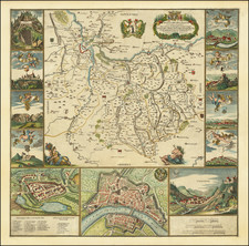
The First Obtainable Map of Savoy.
Rare and finely engraved map of the region around the Duchy of Savoy, published in Venice by the important Lafreri School mapmaker Paolo Forlani, and reissued here in a second state by Ferrando Bertelli. This is the first obtainable map of Savoie, showing the region now split between France, Italy, and Switzerland.
The map is highly detailed, naming cities, and covers a vast swath of territory. The map is oriented with east towards the top. Strasbourg appears in the upper left, Bourgogne and Auvergne in the lower part of the map, and Turin in the upper right. The map is centered on Lake Geneva. The Val d'Aosta appears in the upper right. Grenoble, Geneva, and San Moritz are all named.
The map was long believed to be the earliest modern map of the Duchy of Savoy, until the discovery of a 2 sheet map by Gilles Boileau de Bouillon entitled Nova et exactissima Sabaudie Ducat Descriptio. This French-published map was issued in 1556 and copied by Forlani. Forlani has left the toponyms on the map in French, although he has changed the cartographic indicators to Italian. Boileau de Bouillon's map would be later copied by Ortelius in his 1570 Theatrum.
The Venetian mapmaker Paolo Forlani is one of the best-known and most prolific of the Venetian mapmakers of the period. Forlani and Ferrando Bertelli were two of the most important of a group of 16th-century Italian mapmakers often referred to as "Lafreri School," named for the Roman mapmaker and publisher Antoni Lafreri, who assembled composite atlases of maps published by himself and other Italian mapmakers and added his title page to some examples.
The map carries all the decorative hallmarks of a Lafreri School publication, with its rounded hills, stippled hydrography, and decorative geometric cartouches.
States
The map is known in four states:
- No imprint underneath the scale bar. Known in one example.
- Imprint Ferando Berteli libraro exc. added.
- Imprint changed to Donato Rasciotti forma
- Imprint changed to F. Valeggio forma.
The Lafreri School is a commonly used name for a group of mapmakers, engravers, and publishers who worked in Rome and Venice from ca. 1544 to 1585. The makers, who were loosely connected via business partnerships and collaborations, created maps that were then bound into composite atlases; the maps would be chosen based on the buyer or compiler’s interests. As the maps were initially published as separate-sheets, the style and size of maps included under the umbrella of the “School” differed widely. These differences can also be seen in the surviving Lafreri atlases, which have maps bound in with varying formats including as folded maps, maps with wide, trimmed, or added margins, smaller maps, etc.
The most famous mapmakers of the School included Giacomo Gastaldi and Paolo Forlani, among others. The School’s namesake, Antonio Lafreri, was a map and printseller. His 1572 catalog of his stock, entitled Indice Delle Tavole Moderne Di Geografia Della Maggior Parte Del Mondo, has a similar title to many of the composite atlases and thus his name became associated with the entire output of the larger group.
Paolo Forlani (fl. ca. 1560-1571) was a prolific map engraver based in Venice. All that is known of his life are his surviving maps and prints, of which there are almost 100 (185 with later states included in the total). He also produced a globe and two town books. It is likely he came from Verona and that he died in Venice in the mid-1570s, possibly of the plague.
![[Grand View of Paris] Lutetiae, vulgo, Paris, Urbis Galliarum Primariæ, Non Europæ Solius, Sed Orbis Totius Celeberrimæ Prospectus](https://storage.googleapis.com/raremaps/img/small/77258.jpg)
![[Padua, Treviso] Patavini Territoriorii, Corographia, Iac. Castaldo Auct. [with] Tarvisini Agri Typus](https://storage.googleapis.com/raremaps/img/small/83544.jpg)