


|
||

|

|
|

|
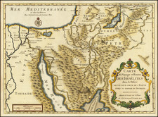
Rare 16th Century Van Doetecum Map of the Exodus of the Children of Israel From Egypt
Fine early map of the Holy Land, engraved by Johannes van Doetecum the Younger, showing the travels of the Children of Israel after the Exodus.
The map is oriented with west at the top. At the upper right, the map begins with the region north of the Nile, including the Cairo, Babylon and Rameses, where the exodus route begins with a large tent and the note "Exod 12." The route proceeds in an easterly direction to the red sea, where the map illustrates the parting of the Red Sea, with Moses atop a rock at the northeast point on the route. From the Red Sea, the route makes a serpentine path to Mount Sinai, where Moses can be seen receiving the Ten Commandments, while below, the others celebrate around the golden calf.
Beyond Mount Sinai, the route becomes circular, keyed to additional passages from Exodus, before reaching the Jordan River, south of the Dead Sea, with Gilal, Jericho and ultimately Jerusalem beyond.
At the lower right corner, the title cartouche surrounded by an image of Aaron, the encampment of the tribes of Israel" and Solomon’s Temple.
At the lower left corner, 3 ships from Solomon's fleet are shown in the Red Sea.
This is one of a series of six maps of the Holy Land engraved by Van Doetecum for bibles issued beginning in the 1590s. This series of maps would become the model for maps which appeared in Dutch, German and other bibles published in the 17th and 18th Centuries. Arguably, his set of maps was the most influential set of Holy Land maps ever published, when one considers the scope of the audience and duration of their legacy.
Rarity
The map is very rare on the market. We were unable to locate a separate example of the map in either AMPR or RBH.
![[Holy Land] Terra Sancta XXIII. Nova Tabula](https://storage.googleapis.com/raremaps/img/small/100585.jpg)
![(Nuremberg Chronicle Leaf) [Moses and the Burning Bush]](https://storage.googleapis.com/raremaps/img/small/98578.jpg)
![De Gelegentheyt van't Paradys en't Landt Canaan mitsgaders d'eerst bewoonde Landen der Patriachen uyt de H. Schristure …[Shows Cyprus]](https://storage.googleapis.com/raremaps/img/small/82746.jpg)