|
||

|

|
|

|
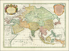
Arnoldi’s Map of Asia—One of the Earliest Accurate Depictions of Luzon
Fine continental map of Asia encompassing Maritime Southeast Asia, the Middle East, Japan, and Arctic Russia. This is only the second Italian map to accurately depict the shape of Luzon in the Philippines.
The map is part of Arnoldi’s series of separately-issued continental maps, all of which are very rare and highly sought-after.
The map is detailed, with blocks of text sharing ethnographic and geographic information about Tartary, which has few cities; China, who provinces are ruled by one powerful Emperor; and Japan, with a mixed political system and some Christian converts. There are also cartographic curiosities here, like Lake Chiamay in the northeast of what is today India.
The ornate title cartouche in the lower left includes a paragraph about the continent. It explains its great size (as big as Europe and Africa combined), not to mention the many surrounding islands that are themselves nearly the size of Europe. It also explains that Asia is the location of earthly paradise and the Holy Land. The people are thought to be ingenious and the monarchies long-lived.
The map includes the Spice Islands, the Moluccas, in detail, as well as the tip of Terra Australe, the mysterious Southern Continent. Of particular interest is the configuration of the Philippines. Unlike Ortelius and Mercator, which only show the southern islands, this map includes the northern islands, specifically Luzon. The latter island is shown in its correct configuration, only the second time this occurred on an Italian map, after Mazzo’s important map. Compare, for example, the recognizable configuration here with that of Rughesi, published only a few years before the present map.
For its cartographic sources, Arnoldi clearly draws on Ortelius for some areas, like Japan, which appears on the Teixera model, as it does on the Ortelius map of the continent. However, the Philippines are drawn much more exactly here than on the Ortelius. For that area, as mentioned above, Arnoldi draws primarily on Giovanni Battista Mazza's rare map of Asia, published ca. 1590. This was part of Mazza’s own exceptionally rare set of continental maps; he was also the engraver of a ten-sheet world map by Rascicotti in 1597. While relatively little is known about Mazza, he clearly benefitted from well-placed sources in Rome as his map incorporates information which would only have been available to connected individuals and would not generally appear on other maps until the seventeenth century.
Because of the rarity of Mazza’s map of Asia, very little historical analysis has been done, other than an article by Richard Casten and Tom Suarez the Map Collector (issue 70, 1995). Casten and Suarez note that among other important firsts in the map of Asia, it was the first map to accurately depict the shape of Luzon in the Philippines. Therefore, this is the second Italian map to capture the correct morphology of this important island.
While the map itself does not include Arnoldi’s name, we can date and identify it thanks to biographical and stylistic evidence. Its visual style is in line with Arnoldi’s other continental maps. His name does appear on the map of Europe, along with his printer’s, Matteo Florimi. Florimi and Arnoldi’s partnership was only forged at the end of Arnoldi’s life, from ca. 1600-1602. The continental maps were dedicated to Scipione Bragaglia, a writer and patron of Arnoldi’s.
Rarity
All of Arnoldi’s works are very rare, either in institutional collections or on the market. This map is held by the British Library, the BNF, Stanford, and the Herzog August Biliothek. The Library of Congress and the John Carter Brown Library have complete sets of the four continental maps.
Lake Chiamay first appeared on a map in 1554 when it was included on the terza tavola in the second edition of volume one of Ramusio’s Delle navigationi et viaggi. Drawn by Giacomo Gastaldi, this map of South and Southeast Asia shows a massive lake from which four rivers flow; these are commonly interpreted as the Chao Phraya, Salween, Irrawaddy, and a branch of the Brahmaputra, but also sometimes include other rivers.
Reports of the lake came from two Portuguese sources: a geographer, João de Barros, and an explorer, Fernão Mendes Pinto. Pinto wrote letters describing a great lake. Barros likely saw these letters. He, in turn, compiled a history of Asia, Décadas da Ásia, that mentioned the lake; Ramusio included Barros’ work in his own compilation of travel and exploration.
Barros describes a lake that begat six rivers, but the map in Ramusio’s work shows only four. However, Gastaldi’s 1561 map, Tertia Pars Asiae, shows six rivers leaving and two entering the lake. After appearing in such an authoritative work, the lake was taken up by other mapmakers. Many used the Ramusio/Gastaldi model. Others innovated on the theme of this geographic chimera, as no such lake exists in the area.
Luis Jorge de Barbuda’s 1584 map shows the lake farther to the north and with a different river pattern. His model was taken up by Hondius in India Orientales (1606) and thereafter by many others. The Jesuit Martino Martini gathered information from his travels in eastern and northern China to compile Imperii Sinarum Nova Descriptio (1655). Martini included the lake, but added the Red River and had the Chao Phraya originate from a different lake. Around 1570, other maps appeared that gave Lake Chiamay only two outlets.
As more Jesuit knowledge of Southeast Asia filtered back to Europe, mapmakers such as Guillaume Delisle began to question the veracity of the lake. It last was added to a map by Vaugondy in 1751; it was reprinted in map reissues, however, until at least 1783. By the early-nineteenth century, the feature was understood to be nothing more than a cartographic myth. By the early-twentieth century, expeditions had definitively proven that no such lake existed.
Arnoldo di Arnoldi (d. 1602) was a Flemish cartographer who worked in Northern Italy at the end of the sixteenth century. Arnoldo was in Bologna by 1595, with his brother, Jacobo, where they worked with Antonio Magini. At the turn of the century, Arnoldi moved to Siena and began to work with Matteo Florimi, Magini’s rival. Arnoldi’s transfer may have contributed to the plagiarism case against Florimi by Magini at the same time. However, Arnoldi died only two years later, in 1602. He is best known for his excellently-wrought world map in ten sheets and his set of continental maps, all of which are extremely rare.
![[ Early Industrial Philippine Logging ] Negros Philippine Lumber Co. & Insular Lumber Co. [with] The Passport of James H. Ramey](https://storage.googleapis.com/raremaps/img/small/77143.jpg)
![Asiatic Archipelago [Early Singapore Inset]](https://storage.googleapis.com/raremaps/img/small/66879.jpg)
![[Asia] (Title in Greek-Turkish Hybrid)](https://storage.googleapis.com/raremaps/img/small/41721.jpg)