|
||

|

|
|

|
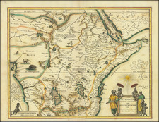
Fine Map of the Guinea Coast, Including the Famous Apes of Dr. Tulp
Detailed map of Guinea, showing the length of a coast important to African-European trade, including the slave trade. Originally drawn by Willem Blaeu in ca. 1635, this example is a later reduced size example, published by Ogilby in London.
The map shows the African coast from Sierra Leone in West Africa to Biafra. As with all European maps of Africa of the mid-seventeenth century, the coastline is much more detailed than the interior, reflecting the state of geographic knowledge about the continent.
Many mountain chains run through the center of the various kingdoms, while settlements are marked with small building symbols that increase in size according to the city’s population or fame. The main geographic feature is the large river running parallel to the top border, the Niger. An inscription near the river explains its dark color and lifegiving qualities in a dry region, like the Nile farther east.
As on Blaeu’s map of the entire continent, seen here, animals roam freely over the interior. Two crocodiles prowl near the Niger, while lions range farther south. Small herds of elephants are in the southwest and southeast, while monkeys explore Guinea. At sea, two compass roses radiate rhumb lines and five ships sail the waters. In the bottom right, two young cherubs carry an elephant tusk aloft.
The Apes of Dr Tulp
The more distinctive decorative elements of the map also carry the most interesting story. A coat of arms and a dedicatory cartouche in the lower left explain that the map is dedicated to Dr. Nicholas Tulp (1593-1674), a member of the Amsterdam government and a celebrated anatomist. The dedication is not meant as a hollow compliment, but as an ode to one of the most famous doctors of the seventeenth century. Tulp is the same doctor seen in Rembrandt’s The Anatomy Lesson (1632). In the painting, Tulp is surrounded by his colleagues who are eagerly watching as Tulp demonstrates the inner workings of a man’s forearm.
Rembrandt’s choice of an arm for the dissection is apt, as Tulp was particularly famous for his work on the anatomy of the arm. Specifically, Tulp had previously dissected the arm of an ape and found that its anatomy was almost the same as a human arm. The specimen was originally from Angola, just to the south of the area shown on this map. Tulp’s notes of the dissection are the earliest accurate description of an ape by a European, although specialists now believe he dissected a bonobo, not a chimpanzee as originally thought.
As a further reference to Dr. Tulp, detailed illustrations of three apes sit atop and on the sides of the title cartouche. The central ape is flanked by two African figures, a man holding beads and a spear, and a woman with beads and a parrot. These items and, sadly, the humans, represent the wealth available in the region depicted and also reflect the prevalence of the appalling slave trade then still in existence.
The maps were included in Blaeu atlases from 1635. Later, they became an important part of the famous Atlas Maior, the most beautiful atlas ever made and then the most expensive books ever produced. The maps of Africa made up roughly one half of volume 9 of the Atlas, sharing space with Spain and Portugal.
This is an exquisitely detailed map that tells an important chapter of the history of African-European exchange.
John Ogilby (1600-1676) was an English geographer and publisher, one of the most prominent of the seventeenth century. Little is known of his early life but by 1619 he was apprenticed to John Draper, a dancing-master in London. He worked as a dancing-master, courtier, and theater owner form 1620-1641. From 1649 he worked as a poet, translator, and publisher of classical texts. It is only in the last decade of his life that he entered into geography.
In 1649, Ogilby published his first translation, of Virgil, and continued to put out translations in the 1650s and 1660s. In March 1661 he was reconfirmed as master of revels in Ireland and appointed master of the king’s imprimeries, or king’s printer. From 1662 to 1665 he was in Ireland, where he most likely met Robert Boyle. He returned to London only to lose much of his printing stock in the Great Fire of 1666. Post-fire, he became assistant surveyor to the city, where he met Robert Hooke and Christopher Wren.
In 1669, Ogilby published Embassy to China. At the same time, he planned to release atlases that would cover the entire world. These atlases would be funded via subscriptions, advertisements, and lotteries—all common practice at the time, especially for expensive multi-volume works. He released Africa and Atlas Japannensis in 1670, America in 1671 and Atlas Chinensis in 1671, and Asia in 1673. Ogilby compiled the works based on materials produced by others and they reflect a growing interest in the wider world within England.
In 1671, while producing the atlases, Ogilby secured another royal title, that of his Majesty’s cosmographer. He used this title when publishing Britannia in 1675, his best-known work. The Britannia is best described as a road atlas; it shows 2519 miles of road in 100 strip maps. This technique would be widely adopted in the subsequent century. His method of measuring with a waywiser, a large wheel, also helped to standardize the distance of the English mile at 1760 yards. The Britannia was a major achievement in early English cartography and was republished in 1698, 1719, and 1720.

![[Democratic Republic of the Congo] Congo Belge](https://storage.googleapis.com/raremaps/img/small/77991.jpg)
![[ Sierra Leone to Côte d'Ivoire ] Pas-caert vande Gryen-Cust en Adaows Qua Quaas Tuhessen de Serraliones en C. de Tres Puntas . . . .](https://storage.googleapis.com/raremaps/img/small/99332.jpg)