|
||

|

|
|

|
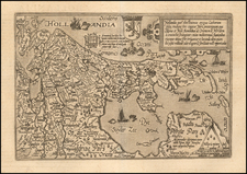
One of the Earliest Printed Maps of Holland Produced in the Low Countries
Rare, separately-published map of Holland, one of the earliest printed maps of the region to be made in the Low Countries.
Oriented to the east, it is also likely the first map of Holland not to be north-oriented, according to the Blonk-Van der Wijsts.
The map bears the imprint of "C.D.H." and is dated 1565. There are two candidates for the maker, Cornelis de Hooghe and Cornelius de Horen (sometimes spelled de Hoorn). However, it is known that de Horen made a map of Holland around this time, thus his attribution is most probable. It was published by Plantijn.
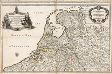
The map shows the densely-settled area that today is part of the Netherlands. It focuses on the province of Holland, but includes part of neighboring provinces as well, like Utrecht. The Zuider Zee is prominent. There are stretches of forest, but most of the region is covered in toponyms of villages, towns, and cities, including Rotterdam, Amsterdam, and the Hague.
The map also has opulent decorative features, such as the delicate floral border. There are three coats of arms, including those of King Philip II of Spain and of William the Silent, the Prince of Orange and Stadtholder of Holland, Zeeland, and Utrecht. The sea is filled with ships in full sail, symbolic of Holland’s bustling commercial activities. A large, elegant compass rose is tucked into the Zuider Zee, while a pair of dividers sits on a scale bar in the lower right corner.
The text cartouche in the lower center of the map describes the geography of Holland in laudatory terms. It is fertile and abounds in cities; indeed, there is no other place so small yet so thickly blanketed with towns.
Rarity
The map is rare. We locate examples at the University of Amsterdam, the Leiden University, and the British Library. This is the first time we have offered the item.
Cornelis de Hooghe was an eccentric and an adventurer, who may have been an illegimate son of Charles V.
Born at The Hague about 1540, he lived 1565-69 at Antwerp and Brussels as a pupil of the well-known engraver Philippe Galle. In 1565 he engraved his map of Holland, dedicated to Prince William I. It has the East at the top and measures 38 by 52 cm. Neither publisher nor author is known.
In 1567 he engraved also a map of the Netherlands in Guicciardini's Descrittione di tutti i Paesi Bassi. For a long time he lived in England, where he engraved a map of Norfolk for the Saxton Atlas.
In 1582 he was at Leiden, but in the following year he was imprisoned as a Spanish spy and on 29 March decapitated and quartered.
![[Low Countries] Provinces Des Pais Bas, Divisees Suivant Les Traites D'Utrecht, De Rastatt, Et D'Anvers, Faits en 1713, 1714 et 1716 Et ou les Nouvelles Barrieres sont Marquees . . . 1737](https://storage.googleapis.com/raremaps/img/small/29903.jpg)