|
||

|

|
|

|
The Second Map To Name Canada and Second Map of The St. Lawrence River Region
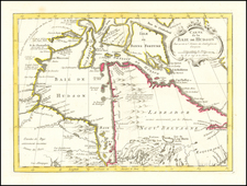
Fine of Johannes Metellus's rare Nova Francia et Canada, the second appearance of the name "Canada" on a printed map, and the second map to focus on the St. Lawrence River and Gulf of St. Lawrence.
Metellus's map was issued one year after the landmark map of Cornelis Wytfliet and follows Wytfliet's cartographic content. Wytfliet's map is a highly important early map of Canada from Wytfliet's Descriptionis Ptolemaicae Augmentum, a pioneering work that set a precedent for the geographic descriptions and atlases of the Americas that followed.
The map depicts Canada from just below Montreal (Hochelaga) on the St. Lawrence, depicting the "known" regions of Canada at the end of the 16th Century. As noted by Burden, map summarizes the sixteenth-century knowledge and explorations in the region on the eve of the first of Samuel de Champlain's voyages into the region. The map is largely derived from the work of Gerard Mercator, although Newfoundland is based upon Cornelis Claesz's map of 1594.
The map provides fine detail on the St. Lawrence River ("Hochelaga flu") and Gulf ("Sinus S. Laurenty") and on the region surrounding the Iroquois settlement of Hochelaga, site of present-day Montreal. Prince Edward Island appears as the "Y. de S. Johan" and Newfoundland is shown as an archipelago with its Portuguese appellation, "Terra de Bacallaos" or "Land of Cod."
Rarity
Metellus's map is rare on the market and highly sought after by collectors.
Johannes Matalius Metellus, also known as Jean Matal or Johannes Metellus Sequanas, was born in Poligny, Burgundy, France in ca. 1517. A humanist scholar, he was a polymath devoted to cartography, geography, law, paleography, and antiquarianism. Late in life he published a series of atlases; all his maps and atlases are rare and highly sought-after.
Matal was educated at Dole, Freiburg, and several Italian institutions. At Bologna, he met Antonio Agustín, a Spanish legal scholar, who recruited Matal to be his secretary. Together, the men researched ecclesiastical law, with an especial emphasis on Roman legal manuscripts, with trips to Venice, Florence, and elsewhere in Italy to study codices. In 1555, the two traveled to England to meet with Queen Mary on a mission for the Church.
After leaving his employment with Agustín, Matal traveled in the Low Countries and eventually settled in Cologne. There, he mixed with other savants, including especially Georg Cassander and Pedro Ximénez. It was in Cologne that Matal began his serious interest in mapmaking. He contributed to Braun and Hogenberg’s Civitae Orbis Terrarum; Georg Braun described him in glowing terms, “vir omni scientiarum genere praestans"—"a man outstanding in every form of knowledge."
Late in life, Matal began preparing a set of maps of the entire world. In 1594, he published an atlas of France, Austria, and Switzerland (39 maps), in 1595 an atlas of Spain (10 maps), and, posthumously, an atlas of Italy (37 maps), and one of Germany and the Netherlands (55 maps). Many of these maps were combined and augmented into atlases of Europe, Asia, Africa, the Americas, and the world’s islands. In 1602, a compendium work showcased all of these previous works called Speculum Orbis Terrae; this atlas was well received by contemporaries like Walter Raleigh and is very rare today. Many of these maps and atlases were released after his death in 1598, they were finished by his friend and fellow mapmaker Conrad Loew (Matthias Quad).
![[Unique Extra-Illustrated Example!] Carte Nouvelle Contenant La Partie d'Amerique La Plus Septentrionale, . . . Le Canada ou Nouvelle France, La Nouvelle Ecosse, La Nouvelle Angleterre, Les Nouveau Pais Bas, La Pensylvanie . . . Et Jle. de Terre Neuve . . .](https://storage.googleapis.com/raremaps/img/small/47720.jpg)
![[Newfoundland] Carta Esferica en dos hojas Del Banco y La Isla De Terranova con parte de la Costa de Labrador, Consruida en la Direccion de Hidrografia seun las ultimas publicadas por el Deposito hidrografico de Londres y presantada a S.S.M.M. por Don Juan de Dios Sotelo . . . 1840](https://storage.googleapis.com/raremaps/img/small/42237sh.jpg)