


|
||

|

|
|

|
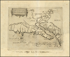
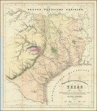
Scarce map of Texas, Upper California, Mexico and the U.S., featuring unusually up to date cartography for the period. The mythical lakes and conjectural rivers of the Western US are removed, evidentally the result of early information from Fremont. The Upper California Missions are named and there nearly a dozen Indian Tribes located, along with other early Spanish Missions in Teexas and the Southwest. Ft. Calhoun is shown on the Missouri and Astoria is named in Oregon. The Mission San Gabriel appears, one of its rare appearances on a map. Santa Catalina Island is also shown. Nice detail throughout.
Pierre Antoine Tardieu (1784-1869), also known to sign his works as PF Tardieu, was a prolific French map engraver and geographer. The Tardieu family, based in Paris, was well known for their talent in engraving, cartography, and illustration. Pierre Antoine’s father, Antoine Francois Tardieu, was an established cartographer who published numerous atlases. His son is said to have collaborated with him for many years before establishing his own independent career.
Pierre Antoine Tardieu’s most famous work includes engravings of the islands of La Palma and Tenerife, for which in 1818 he was awarded a bronze medal by King Louis-Phillipe for the beauty and accuracy of his mapping. Other famous work includes his mapping of Louisiana and Mexico, engravings of Irish counties, maps of Russia and Asia, and his highly celebrated illustrations of all the provinces of France. He was also the first mapmaker to engrave on steel.
Tardieu was a popular map engraver in his lifetime, enjoying the patronage of the likes of Alexander von Humboldt and respect among his peers. In 1837, he was appointed the title Chevalier de la Légion d’honneur. As was written in his obituary in the Bulletin of the Geographical Society of France, he was renowned for his combination of technical talent and scholarly research skills and praised for furthering his family’s well-respected name in the scientific arts.
Perrot was an engineer and mapmaker.
In 1834, Perrot and French artist, zoologist and entomologist Émile Blanchard Nouveau Manuel complet du coloriste, ou Instruction simplifiée et élémentaire pour l'enluminure, le lavis et la retouche des gravures, images, lithographies, planches d'histoire naturelle, cartes géographiques, peinture orientale, plans topographiques, contenant la description des instruments et ustensiles propres au coloriste, la composition, les qualités, le mélange et l'emploi des couleurs et les différents travaux d'enluminure. This work, published in the compact format of Librairie Encyclopédique Roret of Paris, appears to be directed toward people in charge of print and map coloring studios as well as professional colorists, since the content of the work is relatively technical, generally involving the mixing of colors, and the determination of precisely which color to use in coloring specific prints and maps and book illustrations.
![[California, Texas, and Southwest Globe Gore] with [Strait of Anian Globe Gore]](https://storage.googleapis.com/raremaps/img/small/99425.jpg)