


|
||

|

|
|

|
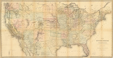
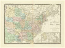
One of the Earliest Wall Maps of the United States Published In America
Rare antique four-sheet wall map of the United States by Samuel Lewis, "Engraved for and Sold By Matthew Carey, Philadelphia."
"Northwest Territory" is shown, predating the appearance of Ohio (statehood granted on February 19, 1803), Indiana Territory (created May 7, 1800), Illinois Territory, and Michigan Territory (created June 30, 1805).
The Lewis map is one of only 5 multi-sheet maps of the United States printed in America prior to 1800. The other 4 (Abel Buell, Osgood Carleton, Abraham Bradley and William MacMurray) are essentially unobtainable.
The first state of Lewis' map incorporates for the first time on a large format map of the United States the newly created Territory of "Tennasee" (which would become a state on June 1, 1796) and Kentucky (which had become a state on June 1, 1792), along with a reasonable well-configured treatment of the District of Maine, which would not become a state until 1820.
Rarity & State
The Carey United States map is rare on the market.
This example is state 3 (of 6), after the additional engraving in the Chesapeake Bay but before the addition of "24" to the upper-left corner.
![(American Revolution - Spanish Mapping) Mapa Geografico Que Comprehende La Nueva Inglaterra, Nueva York, Nueva Jersey, Pensilvania, Maryland y Parte de Virginia. [Geographic Map Encompassing New England, New York, New Jersey, Pennsylvania, Maryland, and Part of Virginia.]](https://storage.googleapis.com/raremaps/img/small/95136.jpg)
![United States History-Map (Five historical maps, including Toscanelli's Map of 1474) [Cover title:] Bacon's Excelsior Wall Atlases - America](https://storage.googleapis.com/raremaps/img/small/88839.jpg)