|
||

|

|
|

|
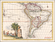
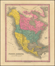
Stunning French Wall Map of the Americas Showing the Sea of the West
Striking, large wall map of North and South America, published in Paris by Jean Baptiste Louis Clouet.
Wall maps with embellished borders were popular in the seventeenth century, when the consumption of maps and their use as decorations in homes and offices came into style in Western Europe. By the time this map was made in 1787, such decorative wall maps were only rarely produced, making this a novel cartographic item of particular note.
The geographic content of the map is largely based upon the work of Joseph Nicolas De L'Isle and Philippe Buache, important French cartographers of the mid-eighteenth century who popularized the Sea of the West, which is included here.
South America is dominated by the two riverine networks of the Amazon and of Rio de la Plata. To the south are the Malouines, or Malvinas, which a note explains are called the Falklands by the English. Tierra del Fuego is shown as one island, with a volcano at its center.
North America is full of the names of Indian tribes, rivers, and mountains. To the north, the large Sea of the West gives way to a series of lakes in the east and then to Hudson’s Bay. The western inland sea has two outlets, one named for Juan de Fuca (misdated by a century to 1692) and the other for Martin Aguilar.
An inset in the top right corner shows the far northwest of North America. The note below explains that the configuration was derived from Russian discoveries and from an Admiral de Fonte. The Russians explored the North Pacific and what is now Alaska on the two expeditions led by Vitus Bering in 1725-30, 1733-43. The date of 1731 listed here is therefore curious.
Admiral de Fonte supposedly sailed to the area in the mid-seventeenth century. The first mention of Fonte appears in two letters published in London in 1708 in two issues of The Monthly Miscellany or Memoirs for the Curious. The Fonte letters had been reprinted by Arthur Dobbs in his 1744 An Account of the Countries adjoining Hudson’s Bay and were mentioned in other travel accounts. Joseph-Nicholas Delisle’s copy of the letters came from Lord Forbes, British ambassador to Russia, as he explained in a memoir, Nouvelles Cartes des Decouvertes de l’Amiral de Fonte (Paris, 1753). He also read of them in Henry Ellis’ account of the 1746-7 expedition to Wager Inlet in Hudson’s Bay.
The letters recounted that Fonte had found an inlet near 53°N which led to a series of lakes. While sailing north east, Fonte eventually met with a Boston merchant ship, commanded by a Captain Shapley. One of Fonte’s captains, separated from the Admiral, reported he had found no strait between the Pacific and the Davis Straits, yet had reached 79°N, helped by local indigenous peoples. This story, with its suggestion of water passages connecting the Pacific Northwest with the east, inspired hope in some and doubt in others in the mid-eighteenth century. A few, like Irish mapmaker John Green, thought the entire story a farce. Many, including De L’Isle, Buache, and Clouet, thought the information conformed neatly to other recent discoveries and included Fonte on their maps.
In the Pacific are several islands and the tracks of explorers. One of these tracks belongs to the first voyage of James Cook, which rounded Cape Horn. Another is labelled as belonging to Louis-Antoine de Bougainville. From 1766-9, Bougainville completed the first French circumnavigation; his was also the second European ship to visit Tahiti, in 1768. However, this map gives credit for the first encounter with Tahiti to Bougainville, although it was well established that Samuel Wallis had visited a few months prior to Bougainville.
The meridian line passes through the Isle de Fer, also known as El Hierro (iron) or Ferro. The island is the westernmost of the Canary Islands and was a much-used meridian outside of Britain. Also marked is the Demarcation Line that separated the Spanish and Portuguese Empires, as decreed by Pope Alexander VI in 1493. This was followed by the Treaty of Tordesillas in 1494, which moved the line farther west.
In the lower corners are two elaborate cartouches. In the left is a French title cartouche which has a European woman holding a cross and an Amerindian man climbing vegetation. To the right, robed individuals (who appear European but are likely meant to be Indigenous American) flank a second title cartouche, this one in Spanish.
Surrounding the map are twenty vignettes. These offer a pictorial history of the New World. It starts with the so-called discovery of America by Europeans, in the top left corner, and continues clockwise to the La Salle expedition at the end of the seventeenth century. Along the left side are imagery and overviews of the leadership of the Incas and Aztecs. Each picture has an explanation in both French and Spanish.
Many European maps of North America in the eighteenth century depict a large, western inland sea, hundreds of miles in diameter, with a small inlet to the Pacific and even some interior islands. The origins of this myth can be traced to several different sources and are tied to the search for a Northwest Passage. Like many cartographic myths, the Sea of the West persisted for decades, even in the face of strong evidence pointing to its non-existence.
One of the first European navigators to supposedly explore this area was Martin Aguilar. A Spanish captain, he sailed with Sebastian Vizcaino on a reconnaissance expedition up the California coast in 1602-3. Aguilar, commanding the Tres Reyes, was blown off course, to the north. When the seas calmed, Aguilar reported that he had found the mouth of a large river. Eighteenth-century geographers later conjectured that the river was the entrance to the Sea of the West.
Other maps placed the entrance to the Sea of the West via the Juan de Fuca Strait. Juan de la Fuca is the Castilianized name of Greek navigator Ioánnis Fokás (Phokás). Little archival evidence survives of Fuca’s career, but a chance meeting with an English financier, Michael Lok, in Venice in 1596 gave birth to rumors of Fuca’s voyages in the Pacific. Fuca reported that he had been sent north from New Spain twice in 1592 in search of the Strait of Anian. The Spanish Crown failed to reward Fuca’s discovery of an opening in the coast at roughly 47° N latitude and Fuca left the Spanish service embittered. His story lived on in Lok’s letters and eventually was published in Samuel Purchas’ travel collection of 1625. On many eighteenth-century maps, Fuca’s Strait is linked with a River or Sea of the West. In 1787, the present-day Juan de Fuca Strait was named by the wife of naval explorer Charles William Barkley, making permanent a label that had previously just been hopeful guesswork.
The source of the modern (18th Century) myth of the Sea or Bay of the West (Baye ou Mer de L'Ouest in French), are manuscript maps by Guillaume De L'Isle, who served as the Royal Geographer to the King of France at the end of the 17th Century and beginning of the 18th Century and is widely regarded as the most important map maker of his time. There is a map in Yale's map collection, which depicts a 16th Century Thames school map of North America with a large, "Branch of the South Sea," which closely resembles De L'Isle's Mer de L'Ouest, and may well be the source of De L'Isle's idea.
At the end of the 17th Century, Guillaume De L'Isle had access to the best available maps of the interior of North America, which were being provided from a number of missionary sources, as the French Missionaries pushed west of the Great Lakes and the Mississippi River and obtained information from the indigenous Indian tribes. De L'Isle was regularly producing and updating his manuscript maps in an attempt to integrate new and often conflicting information and improve upon the existing maps of North America. Many of his maps can be viewed as drafts, which were discarded in favor of other and considerably different models.
There are several De L'Isle manuscripts in the Bibliotheque Nationale de France, prepared as early as 1696 (dated), that depict this cartographic myth. Interestingly, while De L'Isle was a prolific publisher of printed maps, he never depicted the Sea or Bay of the West on any of his printed maps, which strongly suggests that he was not able to reconcile this information with the best available source information from America. During this same period, Jean Baptiste Nolin, who had in the prior decade collaborated with Vincenzo Maria Coronelli on his monumental globe for Louis XIV and produced a series of highly important maps of North America and its regions, would have also had access to many of the same reports and maps as De L'Isle. Nolin apparently gave greater credence to the concept than De L'Isle.
The earliest printed map to show the Bay of the West is Jean Baptiste Nolin's rare wall map of the world, published in about 1700. Nolin plagiarized the idea from Guillaume De L'Isle, as he testified when suing Nolin for plagiarism. He said, the Sea of the West “was one of my discoveries. But since it is not always appropriate to publish what one knows or what one thinks one knows, I have not had this sea engraved on the works that I made public, not wanting foreigners to profit from this discovery” (as quoted in Pedley, The Commerce of Cartography, 109). The court sided with De L'Isle and issued an order requiring Nolin to destroy the copper plates for the map (see Shirley 605). Nolin's map was in turn copied by the Mortier family, who issued 3 world maps shortly thereafter, showing Nolin's version of the Sea of the West, but the myth ignored for nearly half a century.
While the myth of the Sea or Bay of the West temporarily languished, the proliferation of Russian exploration off the Northwest Coast of America after 1740, as reported by Guillaume's younger brother Joseph Nicholas De L'Isle, reinvigorated interest in the region and forced the most prominent map makers of the period to re-examine existing knowledge. Joseph Nicolas served as a geographer to the Russian Academy and returned with this information to Paris. The re-introduction of the sea in the mid-eighteenth century was the result of Guillaume De L’Isle’s son-in-law, Philippe Buache’s review of his father-in-law’s papers. Although Guilluame De L’Isle never published a printed map showing the sea, he had postulated that it could exist, and that it might connect to a Northwest Passage through New France, not through English territory farther north.
The sea was a major part of Buache and Joseph-Nicholas Delisle’s maps of the North Pacific, published in the 1750s. While controversial, the features of those maps were quickly copied by other mapmakers, including the Sea of the West. The inland body of water lingered on maps until the later-eighteenth century.
During a period between 1750 and 1770, the most prominent French and British map makers advanced multiple and widely varying theories on the Northwest Coast of America. Denis Diderot dedicates several of the 10 maps in his monumental Encylopedie (1779 and after), to a comprehensive survey of the maps proffered by Joseph Nicholas De L'Isle (Guillaume's brother), Philippe Buache, Thomas Jefferys and others. The debate ended with Captain James Cook's and later George Vancouver and Comte Jean de la Perouse's explorations in the late 18th Century.
Jean-Baptiste Louis Clouet (1730-ca. 1790) was a mapmaker with premises in both Paris and Cadiz. He was eventually named Royal Geographer of the Academie des Sciences de Rouen. Although he made several lavish wall maps, he is best known for Geographie Moderne (1776-93).