
This item has been sold, but you can enter your email address to be notified if another example becomes available.


|
||

|

|
|

|
Stock# 74846
Description
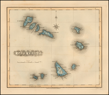
Rare early-19th-century map of Madagascar and the contiguous coastline of East Africa.
Shows excellent detail in the interior of the island, including political subdivisions, topography, and the and mountains.
This is the first time we have ever seen this edition of this map. We have previously had the Vienna 1806 edition.
Condition Description
Two printer's creases in the image.
![[Ethiopia] Jobi Ludolfi Habessinia Seu Abassia Presbyteri Johannis Regio . . . MDCLXXXIII](https://storage.googleapis.com/raremaps/img/small/78394.jpg)

![[Lake Tanganyika, Lake Victoria and Northwest Tanzania]](https://storage.googleapis.com/raremaps/img/small/63611.jpg)