![California [with large inset of Utah and Part of New Mexico] By Charles Morse](https://storage.googleapis.com/raremaps/img/small/92004.jpg)


|
||

|

|
|

|
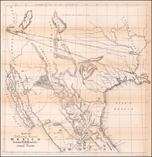
Rare map of California, published in Charles W. Morse's General Atlas of the World, by Appleton & Company of New York.
Morse's map holds the distinction, along with Colton's map of California, as the earliest separate maps of California to appear in Commercial Atlases. The map pre-dates the founding of San Bernardino County, with the south showing only San Diego, Los Angeles, Tulare, Santa Barbara and San Luis Obispo Counties. The map's treatment of Southern California is quite primitive, although the appearance of several wells in the southeastern part of the state is unique.
The detail from Tulare County northward is quite credible. Tahoe is Mountain Lake. Ft. Bishop, Fort Miller and Ft. Washington are shown east of the Sierras, along with an Indian Fort. Massive Tulares Lake still appears. Only 33 California Counties. A fine example of a highly desirable and now rare map of California.
The Morse family were the creator's of the cerographic printing process, which first appeared in their American Atlas and Cerographic Bible atlas, in the 1840s. Prior to that, Jedidiah Morse, the patriarch of the family, was active in the United States publishing maps and geographies prior to 1800 and he and his family carried on the business for nearly 70 years. CW Morse's General Atlas of the World, was the last great work by the Morse family, and the only large format folio size atlas published in the history of the family.

![[ Imperial County / Annotated by County Surveyor ] Denny's Pocket Map of Imperial County](https://storage.googleapis.com/raremaps/img/small/87140.jpg)
![[ California Petroleum ] A Description of the Recently Discovered Petroleum Region in California. With a Report on the Same [with:] Map Representing Locality of The Ojai Ranch in Santa Barbara County, California, belonging to the California Petroleum Company 1865](https://storage.googleapis.com/raremaps/img/small/103844.jpg)