|
||

|

|
|

|
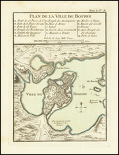
Very rare French-language map of Boston from the time of the French and Indian War. The plan was published by Everard Kints in the Journal encyclopedique ou universal, Liege, March 1757.
The map is based on the famous plan of John Bonner, first issued in 1722, and shows Boston in its characteristic early configuration, as a wide peninsula in the harbor, with a well-defended entrance and bustling city blocks. The information was transferred to Kints through George-Louis Le Rouge's Paris-published 1755 map of Boston, which followed directly from the Bonner.
This map is among the earliest detailed plans of Boston ever published, coming only 35 years after the utterly unobtainable 1722 Bonner Map. Among French and Indian War-era maps of Boston, it is also extremely rare.
Rarity
We have been able to locate only two other examples of the map, at the Boston Athenaeum and American Antiquarian Society.