|
||

|

|
|

|
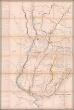
A South American Rarity
Rare Johannes Metellus map of Argentina, Uruguay and the southern part of Brazil, centered on the Rio Plata and showing its watershed and numerous early settlements.
The map is based upon a map of the same title by Cornelis Wytfliet first published in 1597, which appeared in Wytfliet's atlas the first atlas devoted entirely to the Americas and was extremely influential on the mapping of most parts of America for the next several decades.
While Wytfliet's map appears on the market, this Metellus map is very rare and highly prized by collectors.
Cornelius de Wytfliet (ca.1550-ca. 1597) was a Flemish cartographer most famous for his Descriptionis Ptolemaicae Augmentum. The work was published in Louvain, Belgium, and had nineteen maps of the Americas.
![[Moxos Plains, Bolivia]](https://storage.googleapis.com/raremaps/img/small/59593.jpg)
![[San Salvador / Bahia] Carte Reduite De La Baie De Todos os Santos Et De Ses Atterages Situes a la Cote du Bresil Leve in 1819 dans la Campagne de la Corvette la Bayadere et du Brick le Favory par M.M. Givery et Gressier . . . . . . 1823](https://storage.googleapis.com/raremaps/img/small/62801.jpg)
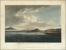
![[Martin Garcia Island, Argentina] Ilha De Martin Garzia](https://storage.googleapis.com/raremaps/img/small/59597.jpg)