


|
||

|

|
|

|
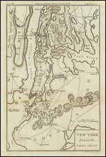
Detailed battle map of the region around Manhattan and New York City.
The map shows Brookland (Brooklyn), Flatbush, Gravesend, New Utrecht, Gowen's Cover, Flatland, Flushing, New Town, Whiston, West Chester, Frogs Neck, East Chester, Bloomingdale, King's Bridge, Fort Independence, Spiking Devil, Jeffery Hook, Cheveux de Friese, Fort Washington, Haerlem, Morrisania, Turtle Bay, Kep's Bay, Robt Murray's House Bergen, Brookland Ferry, Red Hook, Hobock, Redubt and Bushwick Inlet, Horen's Brook, Dykeman's Bridge, and other place names.
Several Battle Plan details, including the March of the Troops under Gen'l Clinton, the Road to Jamaica, the point where Gen'l Grant engaged Ld. Stirling, etc. Numerous roads are also shown. A fine example, in attractive color. The map appeared in Dr. Gordon's History of the American War, one of the best contemporary British Accounts of the Revolution.
![(American Revolution) Geschichte der Revolution von Nord-America. Sammlung der besten Schriftsteller, welche die Geschichte, besondere Rechten, Sitten, und Gewohnheiten der Völker nach ihren Grundsätzen abgehandelt haben [with map:] Die Vereinigten Staaten von Nord=America. nach der Wm. Faden 1783. [History of the Revolution of North America. Collection of the Best Writers Who Have Discussed the History, Specific Laws, Customs, and Habits of the Peoples According to Their Principles [with map:] The United States of North America. According to Wm. Faden, 1783.]](https://storage.googleapis.com/raremaps/img/small/90124.jpg)
![[PT Barnum's American Museum] Barnum's Amerikaansch Museum te New York.](https://storage.googleapis.com/raremaps/img/small/86078.jpg)
![[East Coast of Prince Edward Island - Rollo Bay to Wood Islands]](https://storage.googleapis.com/raremaps/img/small/62849.jpg)
