|
||

|

|
|

|
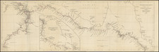
Fine Globular Projection of Asia
Rare four-sheet map of Asia, published in Rome by G. B. Nicolosi. The map employs Nicolosi’s globular projection.
The continent is shown in a sprawling style, although the geographic features are sparser the farther north one looks. Japan is shown in the horizontal orientation typical of the time, while Korea is shown correctly as an island. Southeast Asia, in particular Borneo and Sumatra, and the Philippines are outlined well, especially for a regional map of the period. Intriguingly, Nicolosi locates Singapore (Sincapura) a century and a half before the English would start the process of developing the island as a trade hub.
Some areas, like Papua and New Guinea, contain little information inland. Interestingly, Terra d. Papui is shown as a separate island from Nuoua Guinea based on an error in maps dating to 1590 which confused Irian Jaya (Papua) with the smaller island of Seram. Elsewhere, there is considerable interior detail; for example, the Great Wall of China is shown with a line of towers that greatly resemble the actual structure.
Perhaps of most interest are those coastlines that are not entirely filled in. The shores of Australia are only hinted at, with lightly drawn coasts hugging the neat line in two places. New Guinea is similarly unfinished. The mythical Terra di Iesso is also noted with a speculative coastline.
The treatment of Formosa (Taiwan) is also of note. Between 1624 and 1662 (and again 1664-68), the island was ruled by the Dutch, who established it as Dutch Formosa and instigated colonial rule. The purpose was to build (and possibly monopolize) stable trade relations with Ming China, but also to cultivate rice and sugar using imported Chinese labor. The Dutch presence on the island came to an end within a few years of this map’s publication and so its conclusion constitutes one of those rare windows into a short but decisive period of history.
In 1652, the Propaganda Fide of Rome, which was responsibly for missionary work within the Catholic Church, hired G.B. Nicolosi to compose an atlas. This became his Dell' Hercole e Studio Geografico, published in 1660 and 1671. The four-sheet maps of the continents have become celebrated rarities; they showcase Nicolosi's meticulous work with a quite unusual, yet clean, presentation style. This is the most detailed of the continental maps and suggest that Nicolosi had access to privileged papers and archives.
The map is on a globular projection. This curved projection is often associated with Nicolosi’s name. However, it was originally invented by Abū Rayḥān Muḥammad ibn Aḥmad Al-Bīrūnī, a Muslim scholar active around the year 1000 CE. He used the projection for celestial charts. It is unlikely that Nicolosi knew of the earlier use of the projection when he adapted it from a similar globular projection by Jesuit priest Georges Fournier.
Jesso/Iesso
The etymology of the idiom Yesso (Eso, Yeco, Jesso, Yedso) is most likely the Japanese Ezo-chi; a term used for the lands north of the island of Honshu. During the Edō period (1600-1886), it came to represent the ‘foreigners’ on the Kuril and Sakhalin islands. As European traders came into contact with the Japanese in the seventeenth century, the term was transferred onto European maps, where it was often associated with the island of Hokkaido. It varies on maps from a small island to a near-continent sized mass that stretches from Asia to Alaska.
The toponym held interest for Europeans because the island was supposedly tied to mythic riches. Father Francis Xavier (1506-1552), an early Jesuit missionary to Japan and China, related stories that immense silver mines were to be found on a secluded Japanese island; these stories were echoed in Spanish reports. The rumors became so tenacious and tantalizing that Abraham Ortelius included an island of silver north of Japan on his 1589 map of the Pacific.
The map is relatively rare on the market. This is only the second time we have offered it in twenty-five years.
Giovanni Battista Nicolosi (1610-1670), also known as Giovan Battista, was a Sicilian priest, geographer and cartographer, who worked for the Vatican's Congregation for the Evangelization of Peoples (or Propaganda Fide) under Pope Gregory XV. Officially, the Fide office was established to promote missionary work across the globe, but the reality was that it constituted an important office for the maintenance and dilation of the Church’s power in an ever-expanding world.
Arriving in the papal capital around 1640, Nicolosi devoted himself to the study of letters, sciences, geography and languages. In 1642, he published his Theory of the Terrestrial Globe, a small treatise on mathematical geography, and, a few years later, his guide to geographic study, which was a short treatise on cosmography and cartography. Both works reflected a Ptolemaic world view, but his guide to geographic study would soon serve as an introduction to Nicolosi’s real magnum opus, Dell' Ercole e Studio Geografico, which was first published in 1660. His Theory of the Terrestrial Globe, on the other hand, brought Nicolosi to the attention of broader scientific circles and earned him the Chair in Geography at the University of Rome.
In late 1645, Nicolosi travelled to Germany at the invitation of Ferdinand Maximilian of Baden-Baden, where he remained for several years until returning to Rome. Here, Nicolosi was appointed chaplain of the Borghesiana in the Basilica of Santa Maria Maggiore. This honor was conferred on him by Prince Giovanni Battista Borghese, who Nicolosi himself had tutored and in whose palace he had lived since 1651. Years later, Nicolosi would thank the prince for his generosity by dedicating his most seminal work to him.
One of Nicolosi's most significant contributions to the history of science and geography is the so-called map of the world on a globular projection. First published in 1660, Nicolosi's map of the world, produced ny the Vatican, constituted a pioneering innovation in the way in which the physical world was portrayed. This entirely new perspective on geography was groundbreaking and quickly adapted across the cartographic plane. It has consequently come to be known as the ‘Nicolosi projection’. In truth, Nicolosi's globular projection is a polyconic map projection invented by Abū Rayḥān Muḥammad ibn Aḥmad Al-Bīrūnī, the foremost Muslim scholar of the Islamic Golden Age, who invented the first recorded globular projection for use in celestial maps about the year 1000 CE. Nicolosi was almost certainly not awared of the work of Al-Bīrūnī, and Nicolosi's name it typically attributed to the projection.
There exists in the Vatican and other National archives a considerable collection of Nicolosi’s unpublished work. This includes a large chorographic (i.e. descriptive) map of all of Christendom, commissioned by Pope Alexander VII, as well as a full geographic description and map of the Kingdom of Naples, which was sent to Habsburg Emperor Leopold I in 1654.
![[Southeast Asia, Philippines & India] Nova Delineatio particularis Apostolicarum Peregrinationum noni Indiarum Apostoli in India Orientali](https://storage.googleapis.com/raremaps/img/small/51679.jpg)
![La Tartaria Chinese . . . 1784 [show Corea]](https://storage.googleapis.com/raremaps/img/small/97766.jpg)
![[Melbourne, Australia] We show you Melbourne City, but from a dizzy height. Come see it as we know it, you'll vote it very bright!](https://storage.googleapis.com/raremaps/img/small/94298.jpg)