


|
||

|

|
|

|
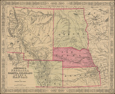
Detailed map of Nebraska, published by GW & CB Colton.
The map is colored by counties. The West is still largely unexplored and uninhabited. Camp Sheridan, Red Cloud Agency and Spotted Tail Agency are among the few settlements in the Northwestern part of the state.
Shows roads, railroads, towns, villages, post offices, rivers, stations and a host of other details.
This is the first separate large format map of Nebraska to appear in a Commercial Atlas.
G. W. & C. B. Colton was a prominent family firm of mapmakers who were leaders in the American map trade in the nineteenth century. The business was founded by Joseph Hutchins Colton (1800-1893) who bought copyrights to existing maps and oversaw their production. By the 1850s, their output had expanded to include original maps, guidebooks, atlases, and railroad maps. Joseph was succeeded by his sons, George Woolworth (1827-1901) and Charles B. Colton (1831-1916). The firm was renamed G. W. & C. B. Colton as a result. George is thought responsible for their best-known work, the General Atlas, originally published under that title in 1857. In 1898, the brothers merged their business and the firm became Colton, Ohman, & Co., which operated until 1901, when August R. Ohman took on the business alone and dropped the Colton name.
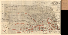

![[Montana, Wyoming, Colorado, Dakotas, etc] Reconnaissances in the Dacota Country By G.K. Warren](https://storage.googleapis.com/raremaps/img/small/82655.jpg)