|
||

|

|
|

|
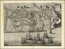
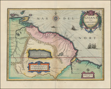
João Pessoa and Fortaleza Santa Catarina Do Cabedelo
Rare map of the area between Frederica Civitas (Fredrikstad / João Pessoa) and Arx Margareta (Fortaleza Santa Catarina Do Cabedelo), showing the course of the Rio Paraiba from João Pessoa to the fort of Santa Catarina do Cabedelo, published by Johannes Blaeu in 1647.
João Pessoa was founded on August 5, 1585, by Portuguese settlers. Called "Royal City of Our Lady of the Snows", its first structures were on the banks of the Sanhauá River, a tributary of the Paraíba River, now known as Porto do Varadouro. In 1588, the city was renamed "Philipeia of Our Lady of the Snows", in honor of King Philip II, who at the time accumulated the thrones of Spain and Portugal.
Around 1586, the Portuguese built a small square fortification, Santa Catarina, on the strategic point of Cabedelo. After an unsuccessful attack in 1631, the Dutch conquered the fort in 1634, rebuilt it to a large extent and renamed it Margareta.
In 1634, attracted by the sugar wealth of the then-capital of the Paraíba, the Dutch invaded and named it Fredrikstad (Frederick City), in honor of the prince of Orange, Frederick of Orange. After the decline of New Holland and with the departure of the Dutch, the city was again dominated by the Portuguese and acquired the name "Parahyba do Norte" in 1654.
Also in 1654, after twenty years of Dutch rule, the fort again fell into Portuguese hands. After 1654, the Portuguese reconstructed the fort in stone around the Dutch ground plan, moving the gate to the landward side.
Joan, or Johannes, Blaeu (1596-1673) was the son of Willem Janszoon Blaeu. He inherited his father’s meticulous and striking mapmaking style and continued the Blaeu workshop until it burned in 1672. Initially, Joan trained as a lawyer, but he decided to join his father’s business rather than practice.
After his father’s death in 1638, Joan and his brother, Cornelis, took over their father’s shop and Joan took on his work as hydrographer to the Dutch East India Company. Joan brought out many important works, including Nova et Accuratissima Terrarum Orbis Tabula, a world map to commemorate the Peace of Westphalia which brought news of Abel Tasman’s voyages in the Pacific to the attention of Europe. This map was used as a template for the world map set in the floor of the Amsterdam Town Hall, the Groote Burger-Zaal, in 1655.
Joan also modified and greatly expanded his father’s Atlas novus, first published in 1635. All the while, Joan was honing his own atlas. He published the Atlas maior between 1662 and 1672. It is one of the most sought-after atlases by collectors and institutions today due to the attention to the detail, quality, and beauty of the maps. He is also known for his town plans and wall maps of the continents. Joan’s productivity slammed to a halt in 1672, when a fire completely destroyed his workshop and stock. Joan died a year later and is buried in the Westerkerk in Amsterdam.
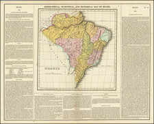
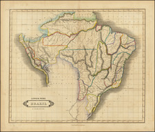
Georg Marcgraff (1610-1644) was a German astronomer and naturalist. In 1637, he was appointed astronomer of a company being formed to sail to the Dutch colony in Brazil. He accompanied Willem Piso, a physician and the newly appointed governor of the Dutch possessions in that country. Later, Marcgraf worked for Johannes Maruitiius of Nassau, who allowed Marcgraf to explore and later mapa considerable part of Brazil. He arrived in Brazil in early 1638 and undertook the first zoological, botanical, and astronomical expedition there, exploring various parts of the colony to study its natural history and geography. He later explored the coast of Guinea, where he died in 1644
During his time in Brazil, Marcgraf and Cornelis Goliath created a map of Brazil, under the sponsorship of Johan Maurits, which was completed in 1643. This map remained the most important ad accurate cartographic representation of Brazil until the 19th century. The Marcgraf Map—actually a series of maps—is illustrated with engravings that offer panoramas of Brazilian life. The illustrations in the map were probably based directly on the drawings of Frans Post, during his 7 years in Brazil as part of the Dutch occupation of the region.