


|
||

|

|
|

|
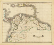
A Rare Early Map of the Eastern Caribbean and Venezuela
Rare early map of the Coast of Venezuela and the Eastern Caribbean, from Hispaniola and Puerto Rico to Curacao and Trinidad & Tobago, published by Johannes Metellus in Cologne.
The map is based upon Cornelis Wytfliet's map of the same title, issued in 1597, but is far rarer than the Wytfliet.
Wyfliet's map is one of the earliest to focus on the coast of Venezuela. As noted by Burden:
In 1597 Cornelis van Wytfliet published his Augmentum to Ptolemy's Geography. This is true in as much as it covers all the Americas, a part of the world unknown to the latter; however, no other connection between them exists. Dedicated to Philip III of Spain it is a history of the New World to date, recording its discovery, natural history etc. For the book Wytfliet had engraved nineteen maps, by whom we do not know, one of the world and eighteen regional maps of the Americas. . . As such this book can be truly called the first atlas of America. It was an immediate success and ran to several editions.
An essential map for regional collectors.
Johannes Matalius Metellus, also known as Jean Matal or Johannes Metellus Sequanas, was born in Poligny, Burgundy, France in ca. 1517. A humanist scholar, he was a polymath devoted to cartography, geography, law, paleography, and antiquarianism. Late in life he published a series of atlases; all his maps and atlases are rare and highly sought-after.
Matal was educated at Dole, Freiburg, and several Italian institutions. At Bologna, he met Antonio Agustín, a Spanish legal scholar, who recruited Matal to be his secretary. Together, the men researched ecclesiastical law, with an especial emphasis on Roman legal manuscripts, with trips to Venice, Florence, and elsewhere in Italy to study codices. In 1555, the two traveled to England to meet with Queen Mary on a mission for the Church.
After leaving his employment with Agustín, Matal traveled in the Low Countries and eventually settled in Cologne. There, he mixed with other savants, including especially Georg Cassander and Pedro Ximénez. It was in Cologne that Matal began his serious interest in mapmaking. He contributed to Braun and Hogenberg’s Civitae Orbis Terrarum; Georg Braun described him in glowing terms, “vir omni scientiarum genere praestans"—"a man outstanding in every form of knowledge."
Late in life, Matal began preparing a set of maps of the entire world. In 1594, he published an atlas of France, Austria, and Switzerland (39 maps), in 1595 an atlas of Spain (10 maps), and, posthumously, an atlas of Italy (37 maps), and one of Germany and the Netherlands (55 maps). Many of these maps were combined and augmented into atlases of Europe, Asia, Africa, the Americas, and the world’s islands. In 1602, a compendium work showcased all of these previous works called Speculum Orbis Terrae; this atlas was well received by contemporaries like Walter Raleigh and is very rare today. Many of these maps and atlases were released after his death in 1598, they were finished by his friend and fellow mapmaker Conrad Loew (Matthias Quad).
![[British Colonies in America] Carte Qui Contient Une Description Des Iles & Terres Que Les Anglois . . .[maps of Chesapeake, Carolinas, New England, Bermuda, Gulf Coast, Jamaica, Barbadoes & Canada]](https://storage.googleapis.com/raremaps/img/small/61480.jpg)


![[Turks & Caicos, Bahamas, Hispaniola and Cuba]. Carte Reduite Des Debouquements, De St. Domingue, Levee, Dressee et Publiee par Ordre du Roi . . . 1787](https://storage.googleapis.com/raremaps/img/small/83475.jpg)