


|
||

|

|
|

|
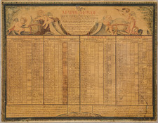
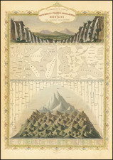
Striking full-color example of a marvelous rendition of the largest mountains, longest rivers, most expansive seas, and widest islands in the eastern hemisphere of the earth. The map is decoratively engraved, and a fine example of this theme of engraving that was popular in the mid-19th century.
At the top of the map are twenty-one waterfalls, all in Europe, depicted falling in unison. Below this, the comparative sizes of seas and islands is particularly interesting: it is fascinating to see the similarities in scale between Madagascar and the Caspian Sea, or the United Kingdom and the Aral Sea. After this, we get to the longest rivers, which is not shown as the Nile but as the Yangtze and the Yenisey. Finally, the depiction of the highest mountains is particularly interesting: not only are fascinating details such as the elevation of the source of the Nile and the snow line included but also the highest elevations reached by hot air balloons, including Joseph Louis Gay-Lussac and Jean Baptiste Biot's trip above 7000 meters.
The map was engraved for R. Montgomery Martin's Illustrated Atlas, by John Tallis, one of the last great decorative map makers. His maps are prized for the wonderful vignettes of indigenous scenes, people, and artifacts they show.
John Tallis (1817-1876) was a British map publisher. Born in the Midlands, Tallis came to London in the 1840s. Tallis began his London career with a series of remarkable London street views. He began a partnership with a Frederick Tallis, possibly his brother, but their collaboration ended in 1849. For the Great Exhibition of 1851, Tallis published the Illustrated World Atlas, one of the last series of decorative world maps ever produced. The maps were engraved by John Rapkin, a skilled artisan. The maps were later reissued by the London Printing & Publishing Company, who left the Tallis imprint intact, thus ensuring his enduring fame. In 1858, he began publication of the popular Illustrated News of the World and National Portrait Gallery of Eminent Personages, selling it in 1861 (it ceased publication in 1863).
![(Horse Diving) [Original photograph of Sonora Carver on her horse Red Lips in mid-air diving off a platform]](https://storage.googleapis.com/raremaps/img/small/96798.jpg)
![[ Florida Native Americans Declaring War ] Bellum denunciandi ratio. XXXIII.](https://storage.googleapis.com/raremaps/img/small/98006.jpg)