


|
||

|

|
|

|
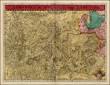
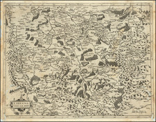
Striking old color example of this two sheet regional map of Champagne and neighboring regions.
Extends south to Dijon, Semeur and Cosne, west to Melun, Lagny and Montdidier, north to Bavay and Chuyn and east to Arlon, Hatton Chatel, and Aigremont. Also shows Auxerre, Troyes, Rheims, Soissons, Chaalons, Laon and La Capelle.
Two large decorative cartouches.
Pierre, or Pieter, Mortier (1661-1711) was a Dutch engraver, son of a French refugee. He was born in Leiden. In 1690 he was granted a privilege to publish French maps in Dutch lands. In 1693 he released the first and accompanying volume of the Neptune Francois. The third followed in 1700. His son, Cornelis (1699-1783), would partner with Johannes Covens I, creating one of the most important map publishing companies of the eighteenth century.
![[Calais] Chales](https://storage.googleapis.com/raremaps/img/small/61301sb.jpg)