|
||

|

|
|

|
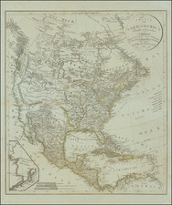
Names the Jefferson River and Maddison River on the Upper Missouri
Interesting map of North America, published by the sons of Felix Delamarche in Paris.
The map shows the western part of North America as it appeared immediately after the conclusion of the Lewis & Clark expedition to the Pacific Ocean. The Clark River, Gallatin River, "Jefferson" River and "Madisson" River are named, tributes to America's third and fourth Presidents.
In the west, the "Limites Occident. Inconnues" illustrates the vast unknown region between the California Coastline and the Rocky Mountains. The first signs of the Great Salt Lake and its mythical cartography (L. de Timpanogos douteux) is shown.
The Port of S. Francois (San Francisco) is shown, a relatively new appearance on the map, as virtually now 18th Century maps illustrated the Bay. Several of the Channel Islands are named, but not the California Missions.
The treatment of the Canadian West reflects information derived from French and Hudson Bay Company fur traders.
The map is colored to suggest that Florida extends to the Mexicano River, including much of East Texas.
![[ First Map to Name The United States ] L'Amerique septentrionale ou se remarquent les Etats Unis . . . 1779](https://storage.googleapis.com/raremaps/img/small/94192.jpg)