|
||

|

|
|

|
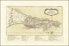
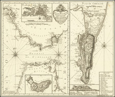
Detailed map of the Bay of Gibraltar, drawn from the work of Louis Claude de Vezou.
The map focuses on the fortified port of Gibraltar and the surrounding Bay of Gibraltar. There are extensive notes regarding the city, bay and rock of Gibraltar. The bay is filled with soundings, anchorages, ocean currents.
There is also a description of the Mountain of Gibraltar and a very detailed description of the Bay of Gibraltar.
Jean Lattré (fl. 1743-1793) was a Parisian bookseller and engraver who published many maps, plans, globes, and atlases. He worked closely with other important French cartographers, including Janvier, Bonne, and Delamarche, as well as other European mapmakers, such as William Faden, Santini, and Zannoni. Lattré is also interesting due to his propensity to bring suits against those who copied his work; plagiarism was common practice in eighteenth-century cartography and mapmakers struggled to maintain proprietary maps and information.
![[Manuscript Map of Gibraltar]](https://storage.googleapis.com/raremaps/img/small/66061.jpg)