|
||

|

|
|

|
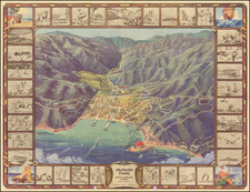
Rare pictorial map of Lake Arrowhead, drawn by western illustrator Raymond Winters.
The map celebrates the summer and winter activities around the lake, including swimming, boating, waterskiing, and fishing along with skiing at local mountains in the winter. Landmarks noted around the lake include North Shore Tavern, The Lodge at Lake Arrowhead, the Village Inn and Lake Shore Cottages.
We date the map in the late 1930s. The Lake Arrowhead Bureau seems to have been in existence in 1937 and 1938. Raymond Winters was a noted Western Illustrator who created a number of pictorial maps in the late 1930s.
Lake Arrowhead
In 1891, three Ohio businessmen chose Little Bear Valley as a likely spot for a reservoir, to supply water to the southern lowlands. Land was purchased and water rights were obtained.
The Arrowhead Reservoir Company was formed. In 1890, a tramway was built from Waterman Canyon up the mountain for the purpose of transporting supplies for the building of the dam. However, engineering problems rendered it unsuccessful. Consequently, supplies and machinery were transported via the switch-back road. Construction of the dam for the reservoir started in 1893. Camp I on the North slope of the Valley served as living quarters and mess hall for the workers.
In 1905, the property was transferred to a new corporation, Arrowhead Reservoir and Power Company, because the idea of utilizing the water for power had been conceived. The dam is what is known as a semi-hydraulic fill dam, 200 feet high, 720 feet long, and 1,100 feet thick at the base. It has a steel reinforced concrete core wall embedded 20 feet in bed rock. The trees and brush were removed from what was the bottom of the lake, so the decay would not be a problem. The lake filled slowly from runoff.
By 1912, the dam was 80% complete, and work continued for several years after that. The plans called for over 60 miles of water conveyances and tunnels. However, only 6 1/2 miles were completed, when it became known that the State ruled in favor of the ranchers on the upper desert side of the Northward facing watershed, and passed laws which prevented the diverting of water from its natural watersheds for other than domestic use. Thus the company was stopped with continuing its plan to transport water to the areas south of the mountains, and even though the lake was filling with water, the project was abandoned.
The Arrowhead Lake Company, a Los Angeles syndicate, bought Little Bear Valley and surrounding land (deriving the name from a natural formation in the form of an arrowhead on the face of the San Bernardino Mountain, near Arrowhead Hot Springs, which is rooted in Indian legend).
The Arrowhead Lake Company’s plan was to develop the mile high man-made lake into a fine recreation and residential area. Between 1921 and 1923, the dam was completed (31 feet higher than originally planned) and a road was constructed partially around the North shore of the lake. The Norman styled village which included a dance pavilion, outdoor movie theater, restaurant, beach and bath houses was completed. Three hotels were built; the Arlington Lodge, Village Inn, and North Shore Tavern. A 9-hole golf course was built on the site of the present golf course. Some of the lake side land was subdivided and was sold for private homes and secluded north shore estates.
Rarity
The map is very rare on the market. This is the only example we have ever seen.
![[Central Riverside County] Riverside Quadrangle](https://storage.googleapis.com/raremaps/img/small/83568.jpg)
![[ Indio, California ] Thousand and One Things to See and Do in this Fascinating World-Famous Desert Wonderland within and surrounding fabulous Coachella Valley [cover title:] Stay in Indio Date Capital of the U.S.A.](https://storage.googleapis.com/raremaps/img/small/90320.jpg)
![Wines from California | Wine Land of America [Vineyard scene]](https://storage.googleapis.com/raremaps/img/small/93655.jpg)