


|
||

|

|
|

|
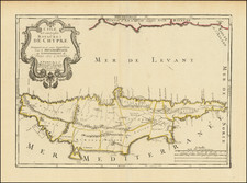
Rare Medieval Map of Cyprus
Rare Early 18th Century map of Cyprus, published by Pierre Moullart-Sanson.
This is one of the rarest and most unusual maps of Cyprus. The map illustrates the eleven "Beylerbeylick" (Ottoman) districts of Cyprus. The map title notes that these were the administrative districts during the Turkish occupation. Stylianou opines that this is the only surviving proof that the Ottoman Empire maintained the French-Venetian districts which pre-dated their conquest of the island.
The map shows both administrative divisions and placenames which date back to medieval times, specifically, the period from the 12th Century to 1570, during which time Cyprus was a Frankish-Latin Kingdom and later a Venetian Colony (1489-1570). It is not certain, however, if the Turks retained the Franco-Venetian districts from 1571 until as late as 1720, or if Moullart-Sanson simply followed the 1570 map of Paolo Forlani.
This is the second map of Cyprus by Pierre Moullart-Sanson, grandson of France's most famous 17th Century mapmaker, Nicolas Sanson. Moullart-Sanson’s earlier map of Cyprus, published in 1718, showed the island with ancient placenames, from prior to the 12th Century. Both of Sanson-Moullart's maps are based upon the outlines and geographical features of a 1570 map drawn by Venetian mapmaker Paolo Forlani.
The history of these two maps has been much studied. It has been observed that there are no surviving atlases which contain both maps. Several commentators have opined that the maps may have been intended for inclusion in book on the history of Cyprus that was never published. While both maps are rare, this 1720 map is especially so with only few known surviving examples as noted below.
The map is known in two states.
- A proof state, known in a single example, with the title and other information in the cartouche in manuscript.
- A second and likely still incomplete state, with the title information now engraved, but the scale of miles still incomplete (4 known institutional examples).
- There is apparently no surviving example of this map with a completed scale.
Rarity
The map is extremely rare on the market. We note only a single example at auction (and no dealer listings) in the past 30 years (Reiss 2009, Sale 128, #3486, which sold for €16,240).
OCLC locates 2 copies (Bibliotheque National de France (D'Anville Collection) and Newberry Library). We note also copies in Bank of Cyprus Cultural Foundation Collection and the Sylvia Ioannou Foundation, which is likely the copy which sold at Reiss in 2009.

![[Cyprus, Holy Land, Syria Middle East] Tabula Asiae IIII](https://storage.googleapis.com/raremaps/img/small/84169.jpg)
![[Holy Land, Cyprus, Syria & Middle East] Asiae IIII Tab](https://storage.googleapis.com/raremaps/img/small/96376.jpg)
![Turkey in Asia [Shows Cyprus]](https://storage.googleapis.com/raremaps/img/small/87364.jpg)