


|
||

|

|
|

|
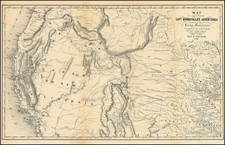
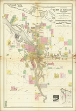
One of the Earliest Obtainable Maps of Portland
Rare early map of Portland, Oregon, published by Whitney and printed by Everts & Howell in Philadelphia.
The map shows Portland and its recent additions along the Willamette River, shaded in different colors to differentiate each location. The lines of several early railroads are shown, as is the Morrison Bridge, Jefferson St. Ferry and Stark St. Ferry, Oregon & California Railroad Bridge, etc.
This is one of a series of maps published by W.H. Whitney, promoting the major towns on the West Coast serviced by the Northern Pacific Railroad. At the bottom left is a statistical table providing an overview of Portland, its local economy and banking information.
Rarity
The map is rare on the market. This is the first example we have seen for sale.
OCLC locates copies at Yale, University of Michigan, University of Minnesota, University of Oregon, Oregon Historical Society and BYU.