|
||

|

|
|

|
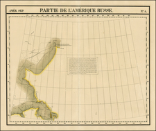
Rare Early Map of the Northwest of North America, including the Northwest Passage.
This is a fine example of Johannes Metellus's map of the Northwest Coast of North America, the third printed map to focus on the region which would become Alaska and the Pacific Northwest.
The map is important in that it is devoted to the Northwest and the Northwest Passage, and is from the second atlas devoted solely to America. While based upon the map of Cornelis Wytfliet published in 1597, Metellus's map is substantially rarer than that of Wytfliet, and thus highly prized by collectors.
The map shows the coast from Northern California to a mythical Northwest Passage in the Arctic Circle, based upon Mercator's large world map of 1569. It shows an area similar to De Jode's Quivirae Regnu of 1593 and Wytfliet's map of 1597, the first printed maps to focus on the area. The nomenclature is from Plancius' World map of 1592.
Certain of the place names are based in history. For example, Quivira Regnum refers to the Seven Cities of Gold sought by the Spanish explorer Francisco Vasquez de Coronado in 1541. In 1539, Coronado wandered over what today is Arizona and New Mexico, eventually heading to what is now Kansas to find the supposedly rich city of Quivira. Although he never found the cities or the gold, the name stuck on maps of southwest North America, wandering from east to west.
Cape Mendocino, also labeled on the map, is a point named by another Spanish explorer, Andres de Urdaneta, in 1565. The point was important to the Acapulco-Manila galleon trade, as the westerly winds pushed the galleons toward this part of the coast, from where they would turn south toward Acapulco.
The majority of the place names and geography north of Cape Mendocino, however, are pure conjecture, as no European would reach this area of the coastline for another 180 years. A number of ambiguous place names, like the River of the Straits and the inlet marked "Great Currents", embellish this largely mythical map.
Although mythical, perhaps the most recognizable place name on the map is Anian. Anian derives from Ania, a Chinese province on a large gulf mentioned in Marco Polo's travels (ch. 5, book 3). The gulf Polo described was actually the Gulf of Tonkin, but the province's description was transposed from Vietnam to the northwest coast of North America. The first map to do was Giacomo Gastaldi's world map in 1562, followed by Zaltieri and Mercator in 1567. The Strait then became shorthand for a passage to China, i.e. a Northwest Passage. It appeared on maps until the mid-eighteenth century.
Rarity
The Metellus map is very rare. This is the first example we have offered for sale.
Johannes Matalius Metellus, also known as Jean Matal or Johannes Metellus Sequanas, was born in Poligny, Burgundy, France in ca. 1517. A humanist scholar, he was a polymath devoted to cartography, geography, law, paleography, and antiquarianism. Late in life he published a series of atlases; all his maps and atlases are rare and highly sought-after.
Matal was educated at Dole, Freiburg, and several Italian institutions. At Bologna, he met Antonio Agustín, a Spanish legal scholar, who recruited Matal to be his secretary. Together, the men researched ecclesiastical law, with an especial emphasis on Roman legal manuscripts, with trips to Venice, Florence, and elsewhere in Italy to study codices. In 1555, the two traveled to England to meet with Queen Mary on a mission for the Church.
After leaving his employment with Agustín, Matal traveled in the Low Countries and eventually settled in Cologne. There, he mixed with other savants, including especially Georg Cassander and Pedro Ximénez. It was in Cologne that Matal began his serious interest in mapmaking. He contributed to Braun and Hogenberg’s Civitae Orbis Terrarum; Georg Braun described him in glowing terms, “vir omni scientiarum genere praestans"—"a man outstanding in every form of knowledge."
Late in life, Matal began preparing a set of maps of the entire world. In 1594, he published an atlas of France, Austria, and Switzerland (39 maps), in 1595 an atlas of Spain (10 maps), and, posthumously, an atlas of Italy (37 maps), and one of Germany and the Netherlands (55 maps). Many of these maps were combined and augmented into atlases of Europe, Asia, Africa, the Americas, and the world’s islands. In 1602, a compendium work showcased all of these previous works called Speculum Orbis Terrae; this atlas was well received by contemporaries like Walter Raleigh and is very rare today. Many of these maps and atlases were released after his death in 1598, they were finished by his friend and fellow mapmaker Conrad Loew (Matthias Quad).

![(Native American Portrait) Man-ce-muckt [Watercolor of Mancemuckt, Chief of the Indians of the Dalles of the Columbia River (i.e. Chief of the Skeen), after Paul Kane]](https://storage.googleapis.com/raremaps/img/small/95030.jpg)