|
||

|

|
|

|
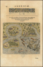
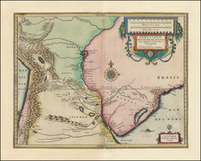
Rare early Dutch map of the area around Fort Frederik Hendrik and Antonio Vaz on the island of Antônio Vaz ('Insula Antonij Vaazij.'), published by Johannes Blaeu in 1647.
The map shows the area around Olinda in Pernambuco at the time of Count Nassau’s arrival in 1637.
Olinda
The settlement of Olinda was founded in 1535 by Duarte Coelho Pereira, from Portugal and became the seat of the Roman Catholic Territorial Prelature of Pernambuco in 1614, and the Diocese of Olinda in 1676. The economy of the region was dominated by the production of sugarcane. This, combined with the importing of slaves from Africa to support cultivation made Olinda a colonial stronghold.
Olinda was the capital of the Portuguese captaincy of Pernambuco, but was burned by Dutch invaders. The Portuguese built their town on the hill, for practical purposes (eg, sewers) and to make it easier to defend. In the 17th century the Kingdom of Portugal was united with Spain (the 1580-1640 Iberian Union). Taking advantage of this period of Portuguese weakness, the area around Olinda and Recife was occupied by the Dutch who gained access to the Portuguese sugarcane plantations.
John Maurice, Prince of Nassau-Siegen was appointed as the governor of the Dutch possessions in Brazil in 1637 by the Dutch West India Company on recommendation of Frederick Henry. He landed at Recife, the port of Pernambuco and the chief stronghold of the Dutch, in January 1637. By a series of successful expeditions, he gradually extended the Dutch possessions from Sergipe on the south to São Luís de Maranhão in the north. He likewise conquered the Portuguese possessions of Saint George del Mina, Saint Thomas, and Luanda, Angola, on the west coast of Africa. After the dissolution of the Iberian Union in 1640, Portugal would reestablish its authority over the lost territories of the Portuguese Empire, including the former Dutch Brazil. Sugarcane plantation slavery would continue to be a source of wealth in Olinda until the Lei Áurea ("Golden Law") abolished slavery in an independent Brazil in 1888.
Joan, or Johannes, Blaeu (1596-1673) was the son of Willem Janszoon Blaeu. He inherited his father’s meticulous and striking mapmaking style and continued the Blaeu workshop until it burned in 1672. Initially, Joan trained as a lawyer, but he decided to join his father’s business rather than practice.
After his father’s death in 1638, Joan and his brother, Cornelis, took over their father’s shop and Joan took on his work as hydrographer to the Dutch East India Company. Joan brought out many important works, including Nova et Accuratissima Terrarum Orbis Tabula, a world map to commemorate the Peace of Westphalia which brought news of Abel Tasman’s voyages in the Pacific to the attention of Europe. This map was used as a template for the world map set in the floor of the Amsterdam Town Hall, the Groote Burger-Zaal, in 1655.
Joan also modified and greatly expanded his father’s Atlas novus, first published in 1635. All the while, Joan was honing his own atlas. He published the Atlas maior between 1662 and 1672. It is one of the most sought-after atlases by collectors and institutions today due to the attention to the detail, quality, and beauty of the maps. He is also known for his town plans and wall maps of the continents. Joan’s productivity slammed to a halt in 1672, when a fire completely destroyed his workshop and stock. Joan died a year later and is buried in the Westerkerk in Amsterdam.
Georg Marcgraff (1610-1644) was a German astronomer and naturalist. In 1637, he was appointed astronomer of a company being formed to sail to the Dutch colony in Brazil. He accompanied Willem Piso, a physician and the newly appointed governor of the Dutch possessions in that country. Later, Marcgraf worked for Johannes Maruitiius of Nassau, who allowed Marcgraf to explore and later mapa considerable part of Brazil. He arrived in Brazil in early 1638 and undertook the first zoological, botanical, and astronomical expedition there, exploring various parts of the colony to study its natural history and geography. He later explored the coast of Guinea, where he died in 1644
During his time in Brazil, Marcgraf and Cornelis Goliath created a map of Brazil, under the sponsorship of Johan Maurits, which was completed in 1643. This map remained the most important ad accurate cartographic representation of Brazil until the 19th century. The Marcgraf Map—actually a series of maps—is illustrated with engravings that offer panoramas of Brazilian life. The illustrations in the map were probably based directly on the drawings of Frans Post, during his 7 years in Brazil as part of the Dutch occupation of the region.
![A collection of five watercolor drawings from the Luso-Hispanic Border Commission in the Amazon Basin, drawn by its Spanish commanding officer: Parte del camino de tierra de Quito al R. Napo (Lamina I); Vista de la Poblacion y Fortaleza de S. Fran[is]co Xavier de Tabatinga (Lamina V); Vista del Salto grande del Rio Yapurà desde la dist.a de 3 Leguas (Lamina X); Vista del Grande Salto inaccesible del Rio Yapurá (Lamina XI); Los Pongos del Rio Marañon [Lamina XVIII].](https://storage.googleapis.com/raremaps/img/small/100698.jpg)