This item has been sold, but you can enter your email address to be notified if another example becomes available.


|
||

|

|
|

|
Stock# 74293
Description
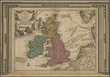
Early Road Map of the British Isles
Fine 4 sheet map of the British Isles, published by Louis Charles Denos in Paris.
The map includes a large cartouche, surmounted by a coat of arms. Includes insets of the Shetlands and Orkneys.
The map focuses on the major roads in the British Isles and shipping routes between England, France and Belgium.
States of the Map / Rarity
The map was first issued in 1716 by Nicolas De Fer. Ther are 8 states of this de Fer plate (see Shirley PMBI-2, de Fer 7.), each dated, and running from 1714 to 1795. The present example is state 5, dated 1766.
All states of the map are rare on the market. We previously offered a 1778 state.
Condition Description
4 sheets, unjoined, as issued. Minor discoloration at folds.
![(British Isles) Tabu Moder Anglie & Hiber [Modern Map of England and Ireland]](https://storage.googleapis.com/raremaps/img/small/103164.jpg)
![[Jamestown, Saint Helena] Plan de la Forteresse et Bourg, De L'Isle De St. Helene](https://storage.googleapis.com/raremaps/img/small/77017.jpg)