|
||

|

|
|

|
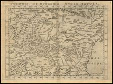
An Important Early Copy of the Lazarus Map of 1528
An exceptional survival, this is the fourth known example of the earliest surviving copy of the Lazerus map of :Hungary published in the Holy Roman Empire.
The Lazarus’ Map of Hungary (Tabula Hungariae) is one of the most important medieval maps of Europe. Surviving in a single example in Budapest, it it is listed in UNESCO's Memory of the World Register and considered a national treasure. The map provides a unique and important look at the Kingdom of Hungary at the beginning of the 16th Century.
The 1528 Tabula Hungariae
The present map, published in 1566 in Vienna, was created from an original drawn by Georg Tannstetter, who in 1528 preserved in print the original Tabula Hungariae, a now lost manuscript map by Hungarian cleric Lazarus Secretarius.The map was created in the light of the rapid advance of the Turks into Central Europe in the first Austrian Turkish War. The history of its origins is described in detail in a cartouche on the right edge: Compiled by Lazerus, revised by Tannsettter edited by Johannes Cuspinianus, dedicated to King Ferdinand and and printed in 1528 in Ingolstadt by Petrus Apianus. Tannstetter's map now survives in a single example in the National Library of Hungary.
The map shows the settlements and landmarks of the Kingdom of Hungary in the early 16th century. The southern areas were then occupied by the Ottoman Empire. As the only covered parts outside the border are in the south, it is thought that the purpose of the creation of the map was the preparations for the war against the Ottomans. Some of the settlements shown on the map vanished during the years of Ottoman wars.
The most valued information on the map are the names and descriptions of settlements. There are approximately 1400 geographical names on the map, of which 1270 are names of settlements (365 on the territory of post-Trianon Hungary.) The geographical names were transcribed differently from modern times. For example, today's é was written ee, today's ö was ew. It is also noted that c is sometimes written tz, which is a characteristic of the Old High German orthography. These may be created by contributors, who prepared the work for printing. However, with some other names, Lázár used the pronunciation of Hungarian dialects.
Lazarus' map, Tabula Hungariae, is considered the oldest survived map of Hungary. The original was made around 1515, while a printed version appeared in 1528 in Ingolstadt. It was a much more detailed depiction than anything produced up to that point, illustrating fortifications, settlements, and some historical events. It is an authentic and very valuable document with respect, also, to the situation in the northern part of present day Serbia, just before the Battle of Mohács and the Ottoman expansion after the battle. After its "re-discovery" in 1906, it became the subject of study for a large number of researchers. It also represents a segment of planetary cultural heritage and, as of 2007, has found its place on UNESCO's Memory of the World Register. The original is kept in the Map Collection Hungarica, at the National Széchényi Library in Budapest.
The Tabula Hungariae is also called Lazarus map, because its manuscript was made by a person called Lazarus, who worked under Archbishop Tamás Bakócz (1497-1521) in the chancellery. Katalin Plihál’s studies during the recent years have revealed a person who perfectly fits the known descriptions, Lazarus Tinódy.
The orientation of this map is quite unusual with geographic north rotated to right by about 40 to 45 degrees. The theories for this orientation are generally (1) the map employs a world projection of Ptolemy or that (2) the map has no specific mathematical orientation.
Twenty-five years after the publication of the original map, the first copies were made in Italy: 1553 by Vavassore (Bifolco / R. 501, Szathmary 39, Szantai Vavassore 2), 1559 by Ligorio (Bifolco / R. 502, Szathmary 47, Szantai Ligorio 1) and Lafreri (Bifolco / R. 503, Szathmary 48, Szantai Lafreri
1a-e).
The Sambucus Edition of the Lazerus Map Published in Vienna
The only copy of the Lazerus map published in the Holy Roman Empire first appeared in 1566. The work of the Hungarian Humanist Johannes Sambucus (János Zsámboky), the map was engraved by Donat Hübschmann. Although by 1566 there were more accurate maps of Hungary (see, for example, the map by Wolfgang Lazius 1552/56), Sambucus used the almost 40 year old model of Lazarus for his first map of Hungary.
Szantai notes: "A work with many mistakes, for example with the reflection of the arms of Hungary. There was a place-name list enclosed to the edge
of the sheet. The list was set in Hungarian, German and Latin. In the text box (Lectori S.) Zsamboki referred to the quick work and promised to work more elaborately next time." Five years later, Zsamboky produced a revised version of the Lazius map, which was copied by Ortelius and used in his atlases from 1579 onwards.
Rarity
Szantai lists only 3 copies of the 1566 Zsamboki map, held in libraries in Budapest, Dillingen and Bologna.
Georg Tannstetter (April 1482 – 26 March 1535), also called Georgius Collimitius, was a humanist teaching at the University of Vienna. \
Tannstetter was a medical doctor, mathematician, astronomer, cartographer, and the personal physician of the emperors Maximilian I and Ferdinand I. He also wrote under the pseudonym of "Lycoripensis". His Latin name "Collimitius" is derived from limes meaning "border" and is a reference to his birth town: "Rain" is a German word for border or boundary.
Born in Rain am Lech in the Duchy of Bavaria, he studied in Ingolstadt. In 1503, he followed a call of Conrad Celtis to the University of Vienna, where he taught mathematics. He soon became a leading figure amongst the humanists in Vienna. In 1510, he became the personal physician of emperor Maximilian I, who would six years later ennoble him with the predicate "von Thanau".
He travelled with his student Joachim Vadian to Buda in 1518. After his earlier work in about 1527 he edited a map of Hungary, today known as Tabula Hungariae, from the manuscript of Lazarus Secretarius, a Hungarian clerk. The map was published by Johannes Cuspinianus, printed 1528 in Ingolstadt by Petrus Apianus. The map now survivese in a single example in the National Library of Hungary. It is generally praised for its details (circa 1300 settlements) and the relative accuracy of the distances between the settlements. It was one of the first regional maps to include a scale but the manuscript was seriously reshaped, so it is difficult to recognize the geography of Hungary.
Tannstetter is also considered a pioneer of the history of science with his work Viri Mathematici, containing biographies of mathematicians at the University of Vienna from the 15th century.
In 1530, he moved to Ferdinand's court at Innsbruck, where he died five years later.
János Zsámboky was a Hungarian physician, philologist, poet, polymath, collector and editor of important manuscripts on Hungarian history, and also an author of historical works.
Zsamboky was born at Nagyszombat (now called Trnava in Slovakia) into a wealthy family. In Vienna in 1542 he graduated, and went on to study philology, ancient languages, law, history, and philosophy in Leipzig, Wittenberg, Ingolstadt, Strasbourg, and Paris where he obtained a master's degree in philosophy in 1551. From 1558 to 1564 he traveled to Venice, Padua, Genoa, Naples, Milan, Ghent, and Antwerp . At the University of Padua, he turned to the study of medicine, becoming the Medical Licentiate in 1555. In 1560 he returned to Vienna, settling down as a physician and leading exponent of scientific and cultural knowledge.
During a trip to Padua he studied medicine and qualified as a physician, a position he held at court on his return to Hungary. Zsamboky wrote the first Hungarian Emblemata, a book containing images with linked texts (the emblems') that were intended to inspire the reader to reflect on a particular moral lesson. His book was published in 1564 and was published through five editions and was translated into French and Dutch.
1581 saw the publication of the first edition of Sambucus' Corpus Iuris Hungarici. The principles contained therein, based on legal strictures of antiquity, contributed to the foundations of the modern day Hungarian legal system.
Sambucus was appointed the court physician of Emperor Maximilian II, as well as the Imperial Council and Hofhistoriograf . From this he obtained a considerable fortune, with which he amassed the largest private library in the world. The library contained numerous previously unknown ancient and contemporary Greek and Latin manuscripts, for instance: Janus Pannonius and Antonio BONFINI, whose texts he partially edited or through his influence supplied patronage to. He also published several maps and geographical descriptions, e.g. "Hungaria", "Transilvaniae Descriptio" and "Illirium", and sometimes wrote Latin poems. Along with his library, he had a large coin and art collection.
Sambucus influenced numerous personalities of the humanistic spirit of his time, many by letter correspondence. He died on June 13, 1584 in Vienna. A plaque commemorates his life at his residence, Singer street in the 1st, House No. 3.
Sambucus' collection of books, maps, coins, and art formed the basis for the manuscript collection of the Austrian National Library .
![[ Turkish Croatia and Austrian Croatia ] Carte Particuliere de la Croatie Autrichienne et Turque, ou est le Theatre de la Guerre Actuelle. Pour Memoire les Hostilites Commencement entre les Autrichiens et les Turcs le 9 Fevrier MDCCLXXXVIII](https://storage.googleapis.com/raremaps/img/small/86157.jpg)