|
||

|

|
|

|
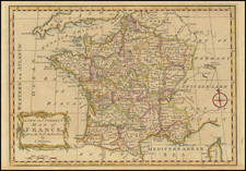
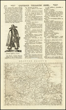
Early Italian Edition of the Oronce Fine Map of 1525
Rare 2 sheet map of France, first published by Paolo Forlani in Venice in 1566.
Dedicated to Marcus Antonius Radici, Forlani's map is based upon Oronce Fine's monumental 4 sheet map of France, the original of which no longer survives.
First published in 1525, Fine's map is the first attempt to create a modern map of France utilizing a systematic series of observations. Fine's map marked an important departure from earlier maps of France, extending its dominion far beyond the limits of Renaissance France. Based on a Gallia bounded by the Rhine, Alps, and Pyrenees, which greatly exceeded the boundaries of Renaissance France, Fine's map pushes even further, extending northern Italy, including Venice and the Adriatic. The coverage in part reflects the ambitions of the kings of France to claim territory in the Alps and Italy, which were dampened by the 1559 treaty of Cateau-Cambrésis, but not entirely defeated.
As noted in the History of Cartography chapter on early mapping in France:
Historical records indicate that Fine’s Nova totivs Galliae descriptio was first published in Paris in 1525 by Simon de Colines . . . and that its final edition was published in 1557. . . However, neither of these editions was preserved. The surviving examples . . . are intermediate printings likely issued from the four woodblocks cut for the original edition. Dated 1538, 1546, and 1554, they were published by Jérôme de Gourmont, a member of the famous family of Parisian booksellers and printers that seemed to specialize in map publishing.
The map was presented by its author as a basic mapping of the country; the cartouche, in part, reads: “our chief intention was to reduce all of Gaul in order to meet the demands of several good men, and to establish and revise the latitudes, longitudes, and situation of main places, coasts, rivers, and the most notable mountains, so that this map can be amplified and corrected at pleasure in the future” . . .
Fine concentrated on Transalpine Gaul as opposed to Cisalpine Gaul situated outside the border of the Alps. The image of Gaul as France was kept distinct from the various Roman “Gauls,” which the author refers to by the toponyms “Gallia belgica,” “Celtica,” “Narbonensis,” and “Cisalpina.”
Fine’s cartographic achievements, based on the compilation of coordinates exemplified by Ptolemy’s Geography, were supported by François I, who created the Collège Royal (the present-day Collège de France) and named Fine as its royal mathematician (regius mathematicus). Trained in mathematical geography, Fine was interested in the calculation of latitudes and longitudes and the construction of new projections. As a geographer, he continued and improved Ptolemy’s work by determining the coordinates of different points of the world on the basis of observations or evaluations. His work was distinct from surveyors’ work, which only measured short distances. Fine proposed to use a modified astrolabe joined to a compass of his own making in determining longitudes from the moon’s path and motion; he named it méthéoroscope géographique.
Fine proposed a list of latitudes and longitudes in De cosmographia (1530; published in 1532 as part 3 of his Protomathesis), using the same prime meridian as Ptolemy, but diverged from Ptolemy in his calculation of the longitudes of such cities as Lyons, Toulouse, Avignon, and Marseilles. His list included the principal cities in Europe, but over half of the coordinates (124) were for French cities. The royal mathematician based his work on the consultation, revision, and expansion of the work of Ptolemy and other classical authorities and on the use of his own observations or evaluations. Thus the work combined the authority of the ancients with the personal experience of its author. According to the cartographic method that Fine put forth in De cosmographia, he first placed points at the positions that had been determined by astronomical and geometrical methods, then added the rivers, and concluded by adding relief and the coasts, beginning with the delineation of capes.
Rarity
The map is scarce on the market. We note only a single example at auctions and in dealer catalogs in the past 15 years.
The Lafreri School is a commonly used name for a group of mapmakers, engravers, and publishers who worked in Rome and Venice from ca. 1544 to 1585. The makers, who were loosely connected via business partnerships and collaborations, created maps that were then bound into composite atlases; the maps would be chosen based on the buyer or compiler’s interests. As the maps were initially published as separate-sheets, the style and size of maps included under the umbrella of the “School” differed widely. These differences can also be seen in the surviving Lafreri atlases, which have maps bound in with varying formats including as folded maps, maps with wide, trimmed, or added margins, smaller maps, etc.
The most famous mapmakers of the School included Giacomo Gastaldi and Paolo Forlani, among others. The School’s namesake, Antonio Lafreri, was a map and printseller. His 1572 catalog of his stock, entitled Indice Delle Tavole Moderne Di Geografia Della Maggior Parte Del Mondo, has a similar title to many of the composite atlases and thus his name became associated with the entire output of the larger group.
Paolo Forlani (fl. ca. 1560-1571) was a prolific map engraver based in Venice. All that is known of his life are his surviving maps and prints, of which there are almost 100 (185 with later states included in the total). He also produced a globe and two town books. It is likely he came from Verona and that he died in Venice in the mid-1570s, possibly of the plague.