|
||

|

|
|

|
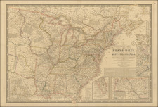
Perhaps The Single Most Enduring Map of the Transmississippi West
Important edition of G.K. Warren's seminal map of the United States, used to illustrate Volume 11 of the US Pacific Railroad Survey.
Lt. Governeur Kemble Warren's monumental map of the Transmississippi West, first issued in 1855, was revised on a number of occasions over the next 2 decades and is, without question, the single most important series of general maps illustrating the exploration, mapping and development of the Transmississippi West.
"Warren's General Map" is a monumentally important map -- the first to provide an accurate overall picture of the region. Wheat considers it so important that he dedicated eight pages to its description and calls it the most important map produced by the Topographical Engineers. The map culminated a half-century of government explorations beginning with Lewis & Clark. Only 24 years old when assigned the task, Warren used information from the U.S. Land Office, the Coast Survey, Topographical Engineers, the Adjutant General, the Quartermaster General, the Indian Bureau, and Smithsonian Institution to obtain the latest information in developing this map. The majority of the map was completed by 1854, but it was not fully complete when the first railroad survey report was published in 1855 and continued to be issued in revised editions until 1868.
During the 1850s, the U.S. Government sponsored a series of expeditions to gather information on the region west of the Misissippi River. The discovery of gold in California accelerated the westward movement and the need for faster transit across the continent.
Secretary of War Jefferson Davis let a monumental surveying effort to locate possible routes to the Pacific. The survey project selected 5 routes, roughly following specific parallels, to be surveyed by Army Topographical Corps.
In all, there were six major expeditions; five of them covered the area between the Great Plains and west coast, and the sixth explored the coastal states of California and Oregon. All of these expeditions were accompanied by naturalists and artists to document the landscape, flora and fauna along the route. The reports, maps and lithographs were published in the highly important 13 volume Explorations and Surveys to ascertain the most practicable and economical route for a Railroad from the Mississippi river to the Pacific Ocean, which was finally completed in 1859 and is frequently referred to as the Pacific Railroad Survey.
The Pacific Railroad Survey became the basic source material for Lt. Gouverneur Kemble Warren's Map of the Territory of the United States from the Mississippi River to the Pacific Ocean. Because of the accelerating flow of new information, Warren recognized, in his Memoir to Accompany the Map, the difficulty of keeping such a map up to date. He stated that "the work of compilation . . . must necessarily be frequently repeated; and to aid the future compiler, I have prepared the accompanying memoir upon the different maps and books used, and upon the manner in which their discrepancies have been resolved." He gratefully acknowledged the work of Edward Freyhold in "the beautiful execution of the topography upon the map . . . ...
The first revision of the map, drawn by Freyhold, was engraved on stone by Julius Bien of New York. The map is in President Millard Fillmore's collection and bears his signature and the date December 19, 1863. This map, like the first edition, lists 45 major surveys and mapping reports from the time of Lewis and Clark to the General Land Office Surveys of the late 1850's.
![The Mother Lode of California [Guide to the Mother Lode Mariposa to Downieville]](https://storage.googleapis.com/raremaps/img/small/97535.jpg)


![[California Road Atlas] Easy Fold Maps of California Highways](https://storage.googleapis.com/raremaps/img/small/73977.jpg)