|
||

|

|
|

|
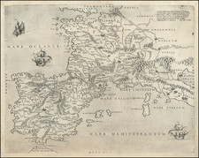
Vintage pictorial map of France showing the route of the 1956 Tour de France.
This edition of the Tour started in Reims before following the northern and western French coasts, then crossed the Pyrenees and the Alps before concluding in Paris. The map also shows French Departments, climbs along the route (including the famous Aubisque and Croix de Fer climbs), and cities along the Tour.
This race started without a clear leader. The famous rider Louison Bobet had to pull out shortly before the start of the race due to cancer surgery, although he would be back to finish the 1958 edition. Midway through the race, the Belgian Adriaensens was in the lead but lost nine minutes due to being ill with supposed food poisoning, although many observers believed the true cause to be doping malpractice. As such, the unknown Frenchman Roger Walkowiak was able to win the race in the final stages.
This map was printed by Miroir-Sprint, a French sports newspaper headquartered in Paris. Advertisements for Perrier, Trigano camping products, and Seram watches are also shown.

![[ Yakima Valley ]](https://storage.googleapis.com/raremaps/img/small/96619.jpg)
![[Imperial Valley]](https://storage.googleapis.com/raremaps/img/small/69292.jpg)