|
||

|

|
|

|
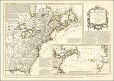
Rare early promotional map showing the route of the Trans-Atlantic Submarine Telegraph lines.
The Transatlantic Telegraph line is an undersea cable running under the Atlantic Ocean used for telegraph communications. The attempt to lay a cable across the floor of the Atlantic occurred August 16, 1858, reducing the communication time between North America and Europe from ten days - the time it took to deliver a message by ship - to a matter of minutes. Cyrus West Field and the Atlantic Telegraph Company were the leading forces behind the construction of the first transatlantic telegraph cable. The project began in 1854 and was completed in 1858. The cable functioned for only three weeks. A second attempt was undertaken in 1865 with much-improved material and, following some setbacks, a connection was completed and put into service on July 28, 1866. In all, Five attempts to lay a cable were made over a nine-year period - one in 1857, two in 1858, one in 1865, and one in 1866. Lasting connections were finally achieved with the 1866 cable and the 1865 cable, after extensive repairs.
The present map was first issued in 1857 and re-issued in 1858, shortly before the completion of the first of the successful cables. The map depicts the route of the undersea telegraph cable across the Atlantic between Newfoundland and Ireland, along with the five principal steamship routes in the North Atlantic, and the railroad lines in North America and Europe (including the yet to be completed Central Pacific Railroad). It also includes an inset map of the Northern Hemisphere, showing the Russian & American Telegraph between St. Petersburg and San Francisco, a profile of the bottom of the North Atlantic as sounded by the American steamer Arctic in 1856, and an actual-size depiction of the undersea cable.
This is the first of two maps issued by the Korff Brothers, with variant states issued in 1856, 1857, and 1858. The firm would issue a new map in 1865: https://www.raremaps.com/gallery/detail/36778
Rarity
The early editions of the map are very rare on the market.