|
||

|

|
|

|
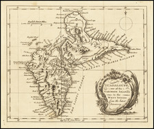
Detailed map of the so called "French Antilles," published by Guillaume De L'Isle in Paris.
The map extends from Guadalupe and Marie-Galante in the north to Grenada and the Grenadines in the south, centered on Saint Lucia and Barbados.
Jean-Claude Dezauche (fl. 1780-1838) was a French map publisher. Initially, his work focused on engraving music, but he later turned primarily to cartography. His is best known for editing and reissuing the maps of Guilluame De L’Isle and Philippe Buache, two of the most skilled mapmakers of the eighteenth century. He acquired the plates of these two men’s work in 1780 from Buache’s heir, Jean-Nicolas Buache. Dezauche's business received a further boon when he received a privilege to sell the charts of the Dépôt de la Marine. His business was carried on by his son, Jean-Andre Dezauche.
![[ Charleston, Boston, New York, St. Augustine, Bahamas, etc ] Particular Draughts of some of the Principal Towns and Harbours belonging to the English French and Spanish in America and the West Indies.](https://storage.googleapis.com/raremaps/img/small/102804.jpg)

![[ Barbadoes ] Novissima et Acuratissima Barbados. Descriptio per Johannem Ogiluium. Cosmographum Regium](https://storage.googleapis.com/raremaps/img/small/86773.jpg)
![[ Aruba ] Kaart van Het Eiland Aruba](https://storage.googleapis.com/raremaps/img/small/99929.jpg)