|
||

|

|
|

|
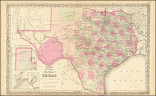
Rare separately published map of Texas, issued by the Oil & Gas Journal in April 1938.
The map provides a detailed snapshot of the oil business in 1938. The map utilizes the Texas Railroad Commission map as a template, with oil and gas data current to March 15, 1938.
The map shows Oil Pipelines, Gas Pipelines, Gas Fields, Oil Fields, Producing Salt Domes, and Refineries.
At the upper left is the large "Generalized Geological Sections of Texas" which locates many formations including those containing oil and gas as well as those to be Known, Probable or Possible "Pay Zones." The huge index to Texas' oil and gas fields lists over 500 fields alphabetically.
The map is white with black printing to indicate counties and major towns. All oil-related information is accomplished with colorful overprinting.
![(The Father of Modern Geology) Charles Lyell Esq.r F.R.S. F.G.S. [with facsimile signature]](https://storage.googleapis.com/raremaps/img/small/86594.jpg)
![Official Texas Brags Map of North America . . . Scale One Inch = 6 Texas Grapefruit [With Original Envelope!]](https://storage.googleapis.com/raremaps/img/small/70748.jpg)
![(Texas - Spanish Colonial Era) [Manuscript document of 1692 concerning Bahia del Espiritu Santo on the Texas Gulf Coast, signed by the Viceroy's secretary, Juan Francisco de Vargas Manuel de Lodeña]](https://storage.googleapis.com/raremaps/img/small/95766.jpg)