|
||

|

|
|

|
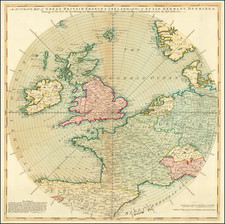
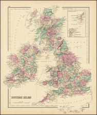
Attractive antique map of the British Isles by Nicolas Visscher II, published in Amsterdam circa 1690.
The map has the coat of arms of the Royal Family in the lower left. In the upper right are the coats of arms of Scotland, England, and Ireland.
The map contains much detail of counties and cities.
Nicolaas Visscher II (1649-1702) was a prominent Dutch cartographer and publisher during the late 17th century. He was the grandson of Claes Janszoon Visscher and the son of Nicolaes Visscher I, both of whom were also renowned cartographers in their own right. After his father's death in 1679, Nicolaas Visscher II took over the family's map publishing business.
In 1680, he married Elizabeth Verseyl from Gouda, and in 1682, he obtained a new privilege from the States of Holland and West Friesland to protect his maps and publications from being copied. Visscher II continued the family tradition of producing high-quality maps, atlases, and globes, often with elaborate and decorative elements. He maintained the Visscher family's reputation for accuracy and craftsmanship in the competitive world of Dutch cartography until his death in 1702. After his death, his widow, Elizabeth, and later his son, also named Nicolaas, continued the business until around 1726.