


|
||

|

|
|

|
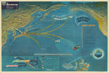
Excellent "NavWar" pictorial map of the Pacific Theater during the Second World War.
The map highlights the progress of American forces in liberating numerous Pacific islands from the Japanese and turning back their advances.
The yellow arrows show the various advances and repulsions of the Japanese military.
A note on the right side of the map documents "Japanese Aggression" from 1895 to 1943.
The map also shows how carrier-based aircraft attacked Japan and then flew into China. Diagrams of the Battle of Midway and Battle of Attu are also shown.
The so-called "NavWarMap" series was published by the Educational Service Section, Bureau of Naval Personnel, Navy Department, Washington, D.C. The Nav War Maps are some of the pictorial maps to have come out of World War II.
The NavWar series included the following maps:
- The Mediterranean
- The South China Sea Area
- World War II in the North Sea Area
- The North Pacific Area
- Southwest Pacific
- We Fight a Global War
![(Second World War - Operation Sea Lion) Stadtdurchfahrtplane England (ohne London) 2. verbesserte Auflage [England transit maps without London]](https://storage.googleapis.com/raremaps/img/small/85951.jpg)